
Ymele:Antarctic-Convergence-Map.TIF

Size of this PNG preview of this TIF file: 514 be 600 dotta. Oðra metinga brædo: 206 be 240 dotta | 411 be 480 dotta | 658 be 768 dotta | 878 be 1,024 dotta | 2,373 be 2,768 dotta.
Frumlicu ymele (2,373 × 2,768 pixela, ymelan micelness: 898 KB, MIME cynn: image/tiff)
Scortness
| Towritenness | Map of the Antarctic Convergence and the Antarctic region. |
| Tælmearc | |
| Fruma |
Published in: L. Ivanov and N. Ivanova. The World of Antarctica. Generis Publishing, 2022. p. 14. ISBN 979-8-88676-403-1 Original Bulgarian version published in: Ivanov, L. and N. Ivanova. Antarctic: Nature, History, Utilization, Geographic Names and Bulgarian Participation. Sofia: Manfred Wörner Foundation, 2014. p. 9 (in Bulgarian) ISBN 978-619-90008-1-6 |
| Dædfruma | own work |
| Other versions | File:Antarctic-Overview-Map.tif, https://commons.wikimedia.org/wiki/File:Antarctic-Overview-Map-EN.tif |
Copyright owner Lyubomir Ivanov alias Apcbg per File:Antarctica-Book-368.TIF.

|
File:Antarctica and the Southern Ocean.svg is a vector version of this file. It should be used in place of this TIF file when not inferior.
File:Antarctic-Convergence-Map.TIF → File:Antarctica and the Southern Ocean.svg
For more information, see Help:SVG. |
 |
Leaf:
This file is licensed under the Creative Commons Attribution-Share Alike 3.0 Unported license.
- Þu most:
- bryttian – to copy, distribute and transmit the work
- to remix – andwendan þæt weorc
- Under the following conditions:
- hlígung – You must give appropriate credit, provide a link to the license, and indicate if changes were made. You may do so in any reasonable manner, but not in any way that suggests the licensor endorses you or your use.
- Efenlice bryttiendlic – Gif þu andwende þis weorc to ohte, þu scleat bryttian þæt andwendede weorc synderlice mid þære ilcan oþþe gelicre leafe swilcre þis brycþ.
Ymelan stær
Swing dæg/tide mid mys to seonne þa ymelan swa heo wæs on þære tide geywed.
| Dæg/Tid | Metungincel | Micelnesse gemetu | Brucend | Ymbspræc | |
|---|---|---|---|---|---|
| nu | 09:20, 27 Blotmonað 2022 |  | 2,373 × 2,768 (898 KB) | Apcbg | style |
| 19:03, 26 Blotmonað 2022 |  | 2,373 × 2,768 (898 KB) | Apcbg | typo fixed | |
| 10:30, 13 Weodmonað 2014 |  | 2,373 × 2,768 (980 KB) | Apcbg | Alexander Island | |
| 12:16, 12 Weodmonað 2014 | 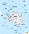 | 2,373 × 2,768 (978 KB) | Apcbg | {{Information |Description=Map of the Antarctic Convergence. |Source=Ivanov, L. and N. Ivanova. Antarctic: Nature, History, Utilization, Geographic Names and Bulgarian Participation. Sofia: Manfred Wörner Foundation, 2014. p. 9 (in Bulgarian) ISBN 97... |
Biliþbendas
Þǣr sind nāne trametas þe bindaþ tō þissum biliðe.
Ymelan eormen nytt
Þas wiki brucaþ þissa ymelena:
- Nytt on bg.wikipedia.org
- Nytt on de.wikipedia.org
- Nytt on en.wikipedia.org
- Nytt on en.wikivoyage.org
- Nytt on es.wikipedia.org
- Nytt on eu.wikipedia.org
- Nytt on fa.wikipedia.org
- Nytt on gl.wikipedia.org
- Nytt on id.wikipedia.org
- Nytt on ko.wikipedia.org
- Nytt on lb.wikipedia.org
- Nytt on lt.wikipedia.org
- Nytt on mk.wikipedia.org
- Nytt on ru.wikipedia.org
- Nytt on uk.wikipedia.org
- Nytt on www.wikidata.org