
Ymele:Uk-map.svg

Size of this PNG preview of this SVG file: 271 be 599 dotta. Oðra metinga brædo: 108 be 240 dotta | 217 be 480 dotta | 347 be 768 dotta | 463 be 1,024 dotta | 927 be 2,048 dotta | 1,021 be 2,255 dotta.
Frumlicu ymele (SVG ymele, rihte 1,021 × 2,255 pixela, ymelan micelness: 204 KB)
Scortness
| Towritenness |
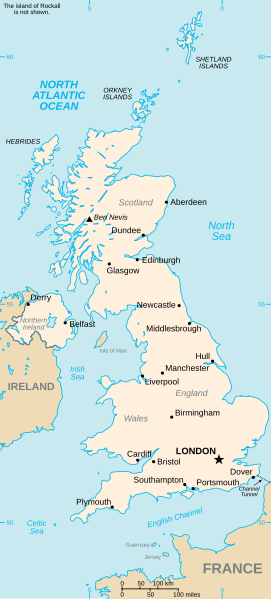
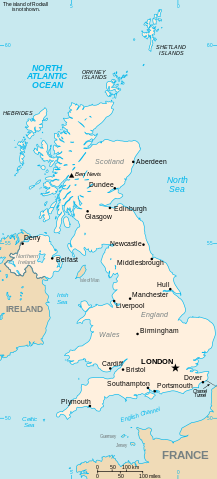
Vector version of CIA WorldBook map of the United Kingdom. Mercator projection. Vector information is from the CIA World DataBank II, and hence in the public domain. |
| Tælmearc | 23 Mædmonað 2006 (original upload date) |
| Fruma | CIA World Factbook |
| Dædfruma | CIA |
| Other versions |
|


Leaf:
This image is in the public domain because it contains materials that originally came from the United States Central Intelligence Agency's World Factbook.
|
 |
Ymelan stær
Swing dæg/tide mid mys to seonne þa ymelan swa heo wæs on þære tide geywed.
| Dæg/Tid | Metungincel | Micelnesse gemetu | Brucend | Ymbspræc | |
|---|---|---|---|---|---|
| nu | 06:22, 5 Hreðmonað 2024 | | 1,021 × 2,255 (204 KB) | Haziq Faruqi | File uploaded using svgtranslate tool (https://svgtranslate.toolforge.org/). Added translation for ms. |
| 17:28, 6 Blotmonað 2023 |  | 1,021 × 2,255 (185 KB) | Belbury | Reverted to version as of 23:32, 23 July 2006 (UTC) better spacing before | |
| 13:43, 18 Eastermonað 2007 |  | 1,021 × 2,255 (128 KB) | Tene~commonswiki | Cleanup | |
| 23:32, 23 Mædmonað 2006 |  | 1,021 × 2,255 (185 KB) | Wereon | added scale | |
| 22:55, 23 Mædmonað 2006 |  | 1,021 × 2,255 (189 KB) | Wereon | Vector version of CIA WorldBook map of the United Kingdom. Vector information is from the CIA World DataBank II, and hence in the public domain. |
Biliþbendas
Þǣr sind nāne trametas þe bindaþ tō þissum biliðe.
Ymelan eormen nytt
Þas wiki brucaþ þissa ymelena:
- Nytt on ar.wikipedia.org
- Nytt on arz.wikipedia.org
- Nytt on be-tarask.wikipedia.org
- Nytt on da.wikipedia.org
- Nytt on de.wikipedia.org
- Nytt on de.wikivoyage.org
- Nytt on el.wikipedia.org
- Nytt on en.wikipedia.org
- Geography of the United Kingdom
- Wikipedia:Recent additions 12
- List of United Kingdom locations
- List of United Kingdom locations: Boa-Bot
- List of United Kingdom locations: Ia-Im
- List of United Kingdom locations: J
- List of United Kingdom locations: Na-Nev
- List of United Kingdom locations: Q
- List of United Kingdom locations: V
- List of United Kingdom locations: X-Z
- List of United Kingdom locations: Bab-Bal
- List of United Kingdom locations: Peo-Pn
- List of United Kingdom locations: Bre-Bri
- List of United Kingdom locations: Bea-Bem
- List of United Kingdom locations: Bam-Bap
- List of United Kingdom locations: Bar
- List of United Kingdom locations: Bas-Baz
- List of United Kingdom locations: Aa-Ak
- List of United Kingdom locations: Al
- List of United Kingdom locations: Am-Ar
- List of United Kingdom locations: As-Az
- List of United Kingdom locations: Bou-Boz
- List of United Kingdom locations: Bur-Bz
- List of United Kingdom locations: Bru-Bun
- List of United Kingdom locations: Ca-Cap
- List of United Kingdom locations: Car-Cd
- List of United Kingdom locations: Chi-Ck
- List of United Kingdom locations: Com-Cor
- List of United Kingdom locations: Cl-Cn
- List of United Kingdom locations: Co-Col
- List of United Kingdom locations: Cos-Cou
- List of United Kingdom locations: Cre-Croc
- List of United Kingdom locations: Cru-Cu
- List of United Kingdom locations: Da-Dam
- List of United Kingdom locations: De-Dee
- List of United Kingdom locations: Eat-Ee
- List of United Kingdom locations: Ea-Eass
- List of United Kingdom locations: East A-East D
- List of United Kingdom locations: Do-Dor
- List of United Kingdom locations: Ds-Dz
- List of United Kingdom locations: Ef-El
- List of United Kingdom locations: Em-Ez
- List of United Kingdom locations: Fa-Fe
View more global usage of this file.