
Ymele:Tarrant County Texas Incorporated Areas Arlington highlighted.svg

Size of this PNG preview of this SVG file: 800 be 436 dotta. Oðra metinga brædo: 320 be 175 dotta | 640 be 349 dotta | 1,024 be 559 dotta | 1,280 be 698 dotta | 2,560 be 1,396 dotta.
Frumlicu ymele (SVG ymele, rihte 1,100 × 600 pixela, ymelan micelness: 235 KB)
Scortness
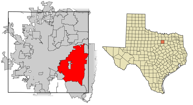
| Towritenness | This map shows the incorporated areas in Tarrant County, Texas. Arlington is highlighted in red. I created it in Inkscape using data from the following links: North Central Texas Council of Governments Maps Website, City of Fort Worth Interactive Zoning Map |
| Tælmearc | |
| Fruma | My own work, based on government information. Though I strove to be as accurate in the detail as possible, the information shown is not guaranteed to be completely accurate. |
| Dædfruma | Ixnayonthetimmay |
| Leaf (Eftnytt þisse ymelan) |
Public Domain |
| Other versions | See Category:Maps of Tarrant County, Texas for other versions of this image. |
Leaf:
| I, the copyright holder of this work, release this work into the public domain. This applies worldwide. In some countries this may not be legally possible; if so: I grant anyone the right to use this work for any purpose, without any conditions, unless such conditions are required by law. |
Ymelan stær
Swing dæg/tide mid mys to seonne þa ymelan swa heo wæs on þære tide geywed.
| Dæg/Tid | Metungincel | Micelnesse gemetu | Brucend | Ymbspræc | |
|---|---|---|---|---|---|
| nu | 10:37, 4 Haligmonað 2007 | | 1,100 × 600 (235 KB) | Ixnayonthetimmay | == Summary == {{Information |Description=This map shows the incorporated areas in Tarrant County, Texas. Arlington is highlighted in red. I created it in [[en:Inksca |
Biliþbendas
Þā folgendan trametas bindaþ tō þissum biliðe:
Ymelan eormen nytt
Þas wiki brucaþ þissa ymelena:
- Nytt on af.wikipedia.org
- Nytt on ar.wikipedia.org
- Nytt on arz.wikipedia.org
- Nytt on bn.wikipedia.org
- Nytt on br.wikipedia.org
- Nytt on ca.wikipedia.org
- Nytt on ceb.wikipedia.org
- Nytt on cs.wikipedia.org
- Nytt on de.wikipedia.org
- Nytt on el.wikipedia.org
- Nytt on en.wikipedia.org
- Nytt on eo.wikipedia.org
- Nytt on es.wikipedia.org
- Nytt on et.wikipedia.org
- Nytt on eu.wikipedia.org
- Nytt on fa.wikipedia.org
- Nytt on fi.wikipedia.org
- Nytt on ga.wikipedia.org
- Nytt on gl.wikipedia.org
- Nytt on hi.wikipedia.org
- Nytt on hr.wikipedia.org
- Nytt on ht.wikipedia.org
- Nytt on hu.wikipedia.org
- Nytt on ia.wikipedia.org
- Nytt on incubator.wikimedia.org
- Nytt on io.wikipedia.org
- Nytt on it.wikipedia.org
- Nytt on ja.wikipedia.org
- Nytt on kw.wikipedia.org
- Nytt on ml.wikipedia.org
- Nytt on ms.wikipedia.org
- Nytt on nl.wikipedia.org
- Nytt on pnb.wikipedia.org
- Nytt on pt.wikipedia.org
- Nytt on ro.wikipedia.org
- Nytt on sc.wikipedia.org
- Nytt on simple.wikipedia.org
- Nytt on sk.wikipedia.org
- Nytt on sl.wikipedia.org
- Nytt on sr.wikipedia.org
- Nytt on sv.wikipedia.org
- Nytt on sw.wikipedia.org
- Nytt on th.wikipedia.org
- Nytt on tr.wikipedia.org
- Nytt on tt.wikipedia.org
- Nytt on ur.wikipedia.org
- Nytt on vo.wikipedia.org
- Nytt on www.wikidata.org
- Nytt on yo.wikipedia.org
- Nytt on zh.wikipedia.org