
Ymele:North German Confederation 1870.svg

Size of this PNG preview of this SVG file: 450 be 456 dotta. Oðra metinga brædo: 237 be 240 dotta | 474 be 480 dotta | 758 be 768 dotta | 1,011 be 1,024 dotta | 2,021 be 2,048 dotta.
Frumlicu ymele (SVG ymele, rihte 450 × 456 pixela, ymelan micelness: 705 KB)
Scortness
This W3C-unspecified vector image was created with Inkscape .


.svg)
.svg)
.svg)
.svg)
.svg)


.svg)
.svg)
.svg)


.png)
.png)


.svg)


.svg)

.svg)


.svg)
.svg)
.svg)
.svg)


.svg)
.png)


.svg)


.svg)
.svg)


.svg)


.svg)


.svg)
.svg)
.svg)
.svg)
.svg)
.svg)
.svg)
_cropped.svg)
.svg)
.svg)
.svg)
.svg)
.svg)
.svg)
.svg)
.svg)
.svg)
.svg)
.svg)
.svg)
.svg)
.svg)
.svg)
.svg)
.svg)
.svg)
.svg)
.svg)
.svg)
.svg)
.svg)
.svg)
.svg)
.svg)
.svg)
.svg)
.svg)
.svg)
.svg)
.svg)
.svg)
.svg)
.svg)
.svg)
.svg)
.svg)
.svg)
.svg)
.svg)
.svg)
.svg)
.svg)
.svg)
Leaf:
This file is licensed under the Creative Commons Attribution-Share Alike 4.0 International license.
- Þu most:
- bryttian – to copy, distribute and transmit the work
- to remix – andwendan þæt weorc
- Under the following conditions:
- hlígung – You must give appropriate credit, provide a link to the license, and indicate if changes were made. You may do so in any reasonable manner, but not in any way that suggests the licensor endorses you or your use.
- Efenlice bryttiendlic – Gif þu andwende þis weorc to ohte, þu scleat bryttian þæt andwendede weorc synderlice mid þære ilcan oþþe gelicre leafe swilcre þis brycþ.
Ymelan stær
Swing dæg/tide mid mys to seonne þa ymelan swa heo wæs on þære tide geywed.
| Dæg/Tid | Metungincel | Micelnesse gemetu | Brucend | Ymbspræc | |
|---|---|---|---|---|---|
| nu | 02:58, 1 Sēremōnaþ 2016 | | 450 × 456 (705 KB) | Alphathon | Various corrections to the states of the North German Confederation |
| 05:22, 31 Þrimilcemonað 2016 |  | 450 × 456 (662 KB) | Alphathon | Uploaded wrong file | |
| 05:22, 31 Þrimilcemonað 2016 |  | 450 × 456 (725 KB) | Alphathon | Minor corrections (Tarasp and post-1818 German Confederation border change) | |
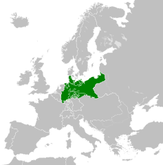
| 02:40, 31 Þrimilcemonað 2016 |  | 450 × 456 (662 KB) | Alphathon | == {{int:filedesc}} == {{Inkscape}} {{Information |Description={{en|A map of the en:North German Confederation within Europe circa 1870 CE.}} |Source= {{Derived from|Blank_map_of_Europe.svg|display=50}} |Date=2016-05-31 |Author=*[[:File:Bla... |
Biliþbendas
Þā folgendan trametas bindaþ tō þissum biliðe:
Ymelan eormen nytt
Þas wiki brucaþ þissa ymelena:
- Nytt on ar.wikipedia.org
- Nytt on azb.wikipedia.org
- Nytt on bg.wikipedia.org
- Nytt on cs.wikipedia.org
- Nytt on en.wikipedia.org
- Nytt on es.wikipedia.org
- Nytt on eu.wikipedia.org
- Nytt on fa.wikipedia.org
- Nytt on fi.wikipedia.org
- Nytt on fr.wikipedia.org
- Nytt on he.wikipedia.org
- Nytt on hr.wikipedia.org
- Nytt on is.wikipedia.org
- Nytt on it.wikipedia.org
- Nytt on ko.wikipedia.org
- Nytt on lt.wikipedia.org
- Nytt on lv.wikipedia.org
- Nytt on ms.wikipedia.org
- Nytt on pl.wikipedia.org
- Nytt on pt.wikipedia.org
- Nytt on ru.wikipedia.org
- Nytt on sv.wikipedia.org
- Nytt on th.wikipedia.org
- Nytt on tr.wikipedia.org
- Nytt on vi.wikipedia.org
- Nytt on zh.wikipedia.org