
Ymele:Maricopa County Incorporated and Planning areas Chandler highlighted.svg

Size of this PNG preview of this SVG file: 694 be 599 dotta. Oðra metinga brædo: 278 be 240 dotta | 556 be 480 dotta | 889 be 768 dotta | 1,185 be 1,024 dotta | 2,371 be 2,048 dotta | 940 be 812 dotta.
Frumlicu ymele (SVG ymele, rihte 940 × 812 pixela, ymelan micelness: 1.05 MB)
Scortness
| Towritenness |
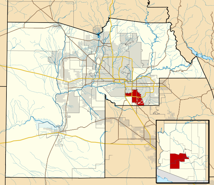
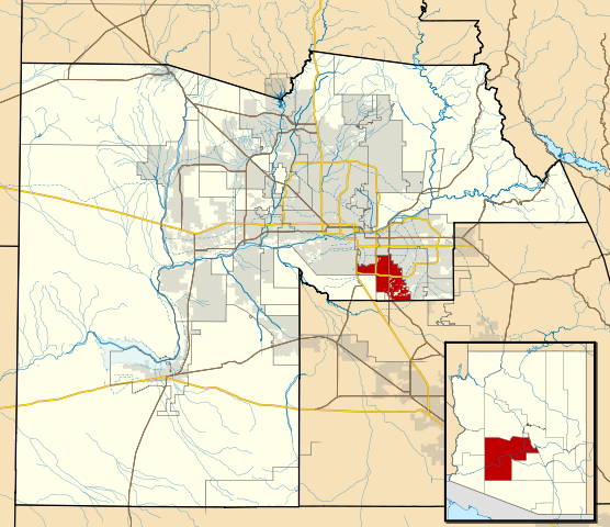
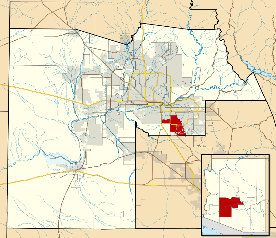
This map shows the incorporated areas and Indian reservation boundaries in Maricopa County, Arizona, along with water bodies and major highways and roads.
|
| Tælmearc | |
| Fruma | My own work, based on government information |
| Dædfruma | Ixnayonthetimmay |
| Leaf (Eftnytt þisse ymelan) |
Public Domain |
| Other versions | See Category:Maps of Maricopa County for other versions of this image. |
Leaf:
| I, the copyright holder of this work, release this work into the public domain. This applies worldwide. In some countries this may not be legally possible; if so: I grant anyone the right to use this work for any purpose, without any conditions, unless such conditions are required by law. |
Ymelan stær
Swing dæg/tide mid mys to seonne þa ymelan swa heo wæs on þære tide geywed.
| Dæg/Tid | Metungincel | Micelnesse gemetu | Brucend | Ymbspræc | |
|---|---|---|---|---|---|
| nu | 06:15, 20 Þrimilcemonað 2011 | | 940 × 812 (1.05 MB) | Ixnayonthetimmay | Uploading new version |
| 04:01, 30 Weodmonað 2008 |  | 900 × 800 (413 KB) | Ixnayonthetimmay | == Summary == {{Information |Description=This map shows the incorporated areas and unincorporated areas in Maricopa County, Arizona. [[:en:Chandler, Arizona| | |
| 23:57, 15 Haligmonað 2007 |  | 900 × 800 (384 KB) | Ixnayonthetimmay | ||
| 23:56, 15 Haligmonað 2007 |  | 900 × 800 (384 KB) | Ixnayonthetimmay | == Summary == {{Information |Description=This map shows the incorporated areas in Maricopa County, Arizona. It also shows the boundaries for the municipal planning areas. The [[:en:Fort | |
| 09:52, 28 Þrimilcemonað 2007 |  | 900 × 780 (329 KB) | Ixnayonthetimmay | ||
| 23:54, 21 Þrimilcemonað 2007 |  | 900 × 780 (318 KB) | Ixnayonthetimmay | ||
| 04:55, 30 Se Æfterra Gēola 2007 |  | 904 × 758 (177 KB) | Ixnayonthetimmay | {{Information |Description=This map shows the incorporated areas in Maricopa County, Arizona, highlighting Chandler in red. It also shows the boundaries for the |
Biliþbendas
Þā folgendan trametas bindaþ tō þissum biliðe:
Ymelan eormen nytt
Þas wiki brucaþ þissa ymelena:
- Nytt on ar.wikipedia.org
- Nytt on arz.wikipedia.org
- Nytt on br.wikipedia.org
- Nytt on ca.wikipedia.org
- Nytt on ceb.wikipedia.org
- Nytt on de.wikipedia.org
- Nytt on el.wikipedia.org
- Nytt on eo.wikipedia.org
- Nytt on es.wikipedia.org
- Nytt on eu.wikipedia.org
- Nytt on fi.wikipedia.org
- Nytt on fr.wikipedia.org
- Nytt on ga.wikipedia.org
- Nytt on glk.wikipedia.org
- Nytt on ht.wikipedia.org
- Nytt on hu.wikipedia.org
- Nytt on id.wikipedia.org
- Nytt on it.wikipedia.org
- Nytt on ja.wikipedia.org
- Nytt on kw.wikipedia.org
- Nytt on mg.wikipedia.org
- Nytt on mzn.wikipedia.org
- Nytt on pl.wikipedia.org
- Nytt on pt.wikipedia.org
- Nytt on ro.wikipedia.org
- Nytt on sr.wikipedia.org
- Nytt on sv.wikipedia.org
- Nytt on sw.wikipedia.org
- Nytt on tt.wikipedia.org
- Nytt on ur.wikipedia.org
- Nytt on vi.wikipedia.org
- Nytt on vo.wikipedia.org
- Nytt on www.wikidata.org
- Nytt on zh.wikipedia.org