
Ymele:Chesapeakelandsat.jpeg
Micelness þisre forebysene: 800 be 600 dotta. Oðra metinga brædo: 320 be 240 dotta | 640 be 480 dotta | 1,024 be 768 dotta.
Frumlicu ymele (1,024 × 768 pixela, ymelan micelness: 164 KB, MIME cynn: image/jpeg)
Scortness
| Towritenness |
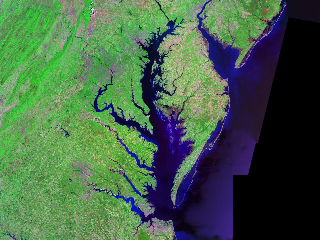
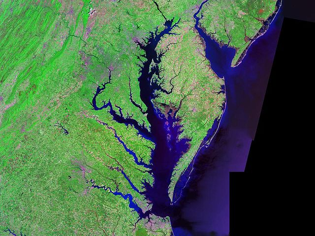
English: Satellite (Landsat) picture of Chesapeake Bay (center) and Delaware Bay (upper right) - and Atlantic coast of the central-eastern United States. |
| Tælmearc | circa 2000 |
| Fruma | Landsat photo, from circa 2000. Generated via [1] from NASA data |
| Dædfruma | Landsat/NASA |
| Other versions |

Leaf:
| This file is in the public domain in the United States because it was solely created by NASA. NASA copyright policy states that "NASA material is not protected by copyright unless noted". (See Template:PD-USGov, NASA copyright policy page or JPL Image Use Policy.) | ||
 |
Warnings:
|
Ymelan stær
Swing dæg/tide mid mys to seonne þa ymelan swa heo wæs on þære tide geywed.
| Dæg/Tid | Metungincel | Micelnesse gemetu | Brucend | Ymbspræc | |
|---|---|---|---|---|---|
| nu | 07:54, 24 Solmonaþ 2005 | | 1,024 × 768 (164 KB) | Balcer~commonswiki | Chesapeake Bay Landsat photo |
Biliþbendas
Þā folgendan trametas bindaþ tō þissum biliðe:
Ymelan eormen nytt
Þas wiki brucaþ þissa ymelena:
- Nytt on af.wikipedia.org
- Nytt on ar.wikipedia.org
- Nytt on ast.wikipedia.org
- Nytt on az.wikipedia.org
- Nytt on be.wikipedia.org
- Nytt on bg.wikipedia.org
- Nytt on br.wikipedia.org
- Nytt on ca.wikipedia.org
- Nytt on ceb.wikipedia.org
- Nytt on da.wikipedia.org
- Nytt on de.wikipedia.org
- Nytt on en.wikipedia.org
- Nytt on eo.wikipedia.org
- Nytt on es.wikipedia.org
- Nytt on et.wikipedia.org
- Nytt on eu.wikipedia.org
- Nytt on fa.wikipedia.org
- Nytt on fi.wikipedia.org
- Nytt on frr.wikipedia.org
- Nytt on fr.wikipedia.org
- Nytt on fy.wikipedia.org
- Nytt on he.wikipedia.org
- Nytt on hu.wikipedia.org
- Nytt on id.wikipedia.org
- Nytt on it.wikipedia.org
- Nytt on ja.wikipedia.org
- Nytt on ka.wikipedia.org
- Nytt on ko.wikipedia.org
- Nytt on la.wikipedia.org
- Nytt on lfn.wikipedia.org
View more global usage of this file.