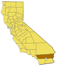
Ymele:California map showing Riverside County.png
Appearance
California_map_showing_Riverside_County.png (200 × 231 pixela, ymelan micelness: 22 KB, MIME cynn: image/png)
Ymelan stær
Swing dæg/tide mid mys to seonne þa ymelan swa heo wæs on þære tide geywed.
| Dæg/Tid | Metungincel | Micelnesse gemetu | Brucend | Ymbspræc | |
|---|---|---|---|---|---|
| nu | 15:23, 14 Mædmonað 2005 |  | 200 × 231 (22 KB) | Pyramide~commonswiki | Map of Riverside county in California. From en: {{GFDL}} Category:Maps of counties in California |
Biliþbendas
Þā folgendan trametas bindaþ tō þissum biliðe:
Ymelan eormen nytt
Þas wiki brucaþ þissa ymelena:
- Nytt on ar.wikipedia.org
- Nytt on arz.wikipedia.org
- Nytt on az.wikipedia.org
- Nytt on be.wikipedia.org
- Nytt on bg.wikipedia.org
- Nytt on ca.wikipedia.org
- Nytt on ceb.wikipedia.org
- Nytt on ce.wikipedia.org
- Nytt on cy.wikipedia.org
- Nytt on el.wikipedia.org
- Nytt on en.wikipedia.org
- Low Desert
- Cucamonga Valley
- Little San Bernardino Mountains
- James Reserve
- Salton Sea State Recreation Area
- La Quinta Resort & Club
- Indio Hills Palms
- Cahuilla County, California
- Coxcomb Mountains
- Eagle Mountains
- Pinto Mountains
- Little Maria Mountains
- Mule Mountains (California)
- Mojave and Colorado Deserts Biosphere Reserve
- Hexie Mountains
- San Gorgonio River
- Prado Reservoir
- Template:RiversideCountyCA-geo-stub
- North Palm Springs, California
- Vail Lake
- Reinhardt Canyon
- Midland, California
- Temecula Valley
- Eureka Peak (California)
- Valerie Jean Dates
- Pinyon Pines, California
- Salt Creek (Salton Sea)
- Chino Canyon (California)
- Chino Fault
- Black Hills (Riverside County)
- Cottonwood Mountains (Riverside County)
- Domenigoni Mountains
- Indio Hills
- Jurupa Mountains
- Kalmia Hills
- Little Chuckwalla Mountains
- Pedley Hills
- Rawson Mountains (California)
- Santa Rosa Hills (Riverside County)
- The Badlands (California)
View more global usage of this file.


