
Ymele:Bangladesh divisions english.png
Micelness þisre forebysene: 439 be 599 dotta. Oðra metinga brædo: 176 be 240 dotta | 500 be 682 dotta.
Frumlicu ymele (500 × 682 pixela, ymelan micelness: 19 KB, MIME cynn: image/png)
Scortness
| Towritenness |
Español: Divisiones de Bangladesh
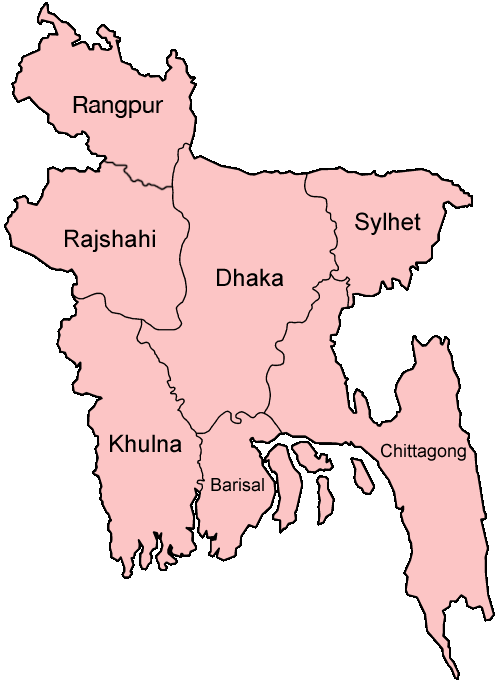
Map of the divisions of Bangladesh in English. Made by User:Golbez. |
| Tælmearc | 31 Ærra Geola 2005 (original upload date) |
| Fruma | No machine-readable source provided. Own work assumed (based on copyright claims). |
| Dædfruma | No machine-readable author provided. Golbez assumed (based on copyright claims). |
derivative works
Derivative works of this file: Bangladesh location map-Rangpur Division.svg
Leaf:
I, the copyright holder of this work, hereby publish it under the following licenses:

|
Permission is granted to copy, distribute and/or modify this document under the terms of the GNU Free Documentation License, Version 1.2 or any later version published by the Free Software Foundation; with no Invariant Sections, no Front-Cover Texts, and no Back-Cover Texts. A copy of the license is included in the section entitled GNU Free Documentation License. |
| This file is licensed under the Creative Commons Attribution-Share Alike 3.0 Unported license. | ||
| ||
| This licensing tag was added to this file as part of the GFDL licensing update. |
This file is licensed under the Creative Commons Attribution 2.5 Generic license.
- Þu most:
- bryttian – to copy, distribute and transmit the work
- to remix – andwendan þæt weorc
- Under the following conditions:
- hlígung – You must give appropriate credit, provide a link to the license, and indicate if changes were made. You may do so in any reasonable manner, but not in any way that suggests the licensor endorses you or your use.
Þu most ceosan leafe
Ymelan stær
Swing dæg/tide mid mys to seonne þa ymelan swa heo wæs on þære tide geywed.
| Dæg/Tid | Metungincel | Micelnesse gemetu | Brucend | Ymbspræc | |
|---|---|---|---|---|---|
| nu | 19:40, 27 Se Æfterra Gēola 2010 | | 500 × 682 (19 KB) | NordNordWest | update Rangpur |
| 00:28, 1 Hreðmonað 2009 |  | 500 × 682 (19 KB) | Mahahahaneapneap | Compressed | |
| 02:52, 31 Gēolmōnaþ 2005 |  | 500 × 682 (20 KB) | Golbez | Map of the divisions of Bangladesh in English. Made by User:Golbez. Category:Maps of Bangladesh |
Biliþbendas
Þǣr sind nāne trametas þe bindaþ tō þissum biliðe.
Ymelan eormen nytt
Þas wiki brucaþ þissa ymelena:
- Nytt on ar.wikipedia.org
- Nytt on ast.wikipedia.org
- Nytt on ca.wikipedia.org
- Nytt on de.wikipedia.org
- Nytt on en.wikipedia.org
- Wikipedia:WikiProject Bangladesh
- Wikipedia:WikiProject Bangladesh/History Workgroup
- User:Jonny-mt/Gallery of current first-level administrative country subdivisions maps
- Wikipedia:WikiProject Bangladesh/Geography Workgroup
- Talk:Bangladesh/Archive 3
- Wikipedia:WikiProject Bangladesh/ResourcesBangladesh
- Wikipedia:Graphics Lab/Map workshop/Archive/Aug 2010
- Nytt on eo.wikipedia.org
- Nytt on fi.wikipedia.org
- Nytt on fr.wikipedia.org
- Nytt on gl.wikipedia.org
- Nytt on hi.wikipedia.org
- बांग्लादेश
- सिलहट विभाग
- चट्टग्राम विभाग
- ढाका जिला
- ढाका विभाग
- राजशाही विभाग
- खुलना विभाग
- बरिशाल विभाग
- नरसिंगडी जिला
- मानिकगंज जिला
- मुंशीगंज जिला
- नारायनगंज जिला
- मैमनसिंह जिला
- शेरपुर जिला
- जमालपुर जिला
- नेत्रोकोना जिला
- गाजीपुर जिला (बांग्लादेश)
- किशोरगंज जिला
- टंगाइल जिला
- फरीदपुर जिला
- मदारीपुर जिला
- शरियतपुर जिला
- राजबाड़ी जिला
- बगेरहाट जिला
- चौडांगा जिला
- येशोर जिला
- झेनईदह जिला
- खुलना जिला
- कुश्तिया जिला
- मगुरा जिला
- मेहरपुर जिला
View more global usage of this file.