Ymele:A plat of all the world - Norman B. Leventhal Map Center at the BPL.jpg

Page contents not supported in other languages.
Fram Wikipǣdian

Frumlicu ymele(2,000 × 1,343 pixela, ymelan micelness: 2.37 MB, MIME cynn: image/jpeg)

Þeos ymele is fram Wikimedia Commons and man mot brucan hire on oðrum weorcum. Seo amearcung on hire tramete ymelan amearcunge þær is her geywed.

Scortness

Towritenness

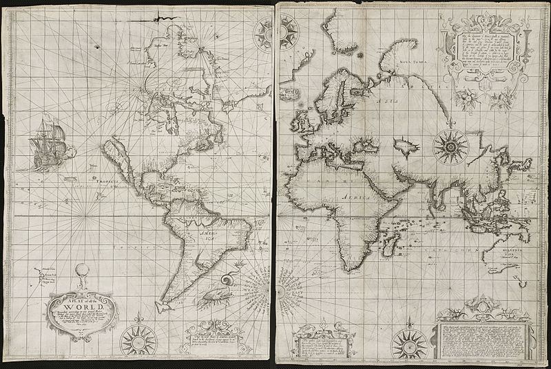
Zoom into this map at maps.bpl.org. Author: Wright, Edward Publisher: Joseph Moxon Date: [1657], 1655.


Scale: Scale not given.

BPL Call Number: G3200 1657.W7 View at the Norman B. Leventhal Map Center


In attempting to compete with the Dutch production of nautical charts at the end of the 16th century, the British mathematician and hydrographer Edward Wright published a navigational guide entitled Certaine Errors of Navigation. This 1599 publication included a world map which was one of the first to use the cylindrical projection introduced by Gerard Mercator in 1569. Wright's treatise on navigation along with the world map were reissued in 1657 by Joseph Moxon, a London instrument and globe maker, as well as the royal hydrographer. Moxon reworked the map, as displayed here, decorating it with five compass roses, images of a ship and a sea monster, and five ornamented text boxes. Of particular note is the title cartouche which was topped by an image of Atlas holding the Earth, a motif that was just starting to be used on atlas title pages, but also was suggestive of Moxon's address as indicated on the map, "Sold at his Shop in Cornhill at the sign of Atlas." Moxon made revisions to the geographic information, reflecting new discoveries around Hudson's Bay and Australia. He also accepted the mistaken notion of California as an island, which was becoming a prevalent image on mid-17th-century English and Dutch maps. Although the size and shapes of land masses, especially in the polar regions, are greatly exaggerated on world maps using the Mercator projection, Wright's use of this projection was entirely appropriate, because the projection was originally developed for navigational purposes. The Mercator projection is noted for showing true compass direction (North, East, South, or West) any where on the map. This property is highlighted on Moxon's version of the map by the five compass roses, and especially the one centrally located in the South Atlantic, naming the cardinal as well as many intermediate directions.
Tælmearc
Fruma A plat of all the world
Dædfruma http://maps.bpl.org

Leaf:

w:en:Creative Commons
hlígung
This file is licensed under the Creative Commons Attribution 2.0 Generic license.
Þu most:
  • bryttian – to copy, distribute and transmit the work
  • to remix – andwendan þæt weorc
Under the following conditions:
  • hlígung – You must give appropriate credit, provide a link to the license, and indicate if changes were made. You may do so in any reasonable manner, but not in any way that suggests the licensor endorses you or your use.
This image was originally posted to Flickr by Norman B. Leventhal Map Center at the BPL at https://www.flickr.com/photos/24528911@N05/2709980753. It was reviewed on 2 Mædmonað 2012 by FlickreviewR and was confirmed to be licensed under the terms of the cc-by-2.0.

2 Mædmonað 2012

Captions

Add a one-line explanation of what this file represents

Items portrayed in this file

depicts English

creator English

some value

copyrighted English

inception English

10 Mædmonað 2008

media type English

image/jpeg

checksum English

faf57840342a0bc4a302fd6956070e399e43ed8a

determination method English: SHA-1 English

data size English

2,481,062 Bita

height English

1,343 pixel

width English

2,000 pixel

Ymelan stær

Swing dæg/tide mid mys to seonne þa ymelan swa heo wæs on þære tide geywed.

Dæg/TidMetungincelMicelnesse gemetuBrucendYmbspræc
nu01:42, 2 Mædmonað 2012Metungincel þære fadunge fram 01:42 on 2 Mædmonað 20122,000 × 1,343 (2.37 MB)Dzlinker== {{int:filedesc}} == {{Information |Description=Zoom into [http://maps.bpl.org/id/M8788/ this map] at [http://maps.bpl.org maps.bpl.org]. '''Author:''' Wright, Edward '''Publisher:''' Joseph Moxon '''Date:''' [1657], 1655. '''Scale:''' Scale not gi...

Þǣr sind nāne trametas þe bindaþ tō þissum biliðe.

Ymelan eormen nytt

Þas wiki brucaþ þissa ymelena:

  • Nytt on simple.wikipedia.org
  • Nytt on xh.wikipedia.org

Metagefræge