
Ymele:Sani Pass heading into Lesotho.jpg

Micelness þisre forebysene: 800 be 532 dotta. Oðra metinga brædo: 320 be 213 dotta | 640 be 425 dotta | 1,024 be 680 dotta | 1,280 be 850 dotta | 1,600 be 1,063 dotta.
Frumlicu ymele (1,600 × 1,063 pixela, ymelan micelness: 2.24 MB, MIME cynn: image/jpeg)
Scortness
| Towritenness |
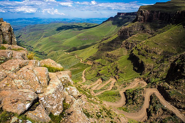
English: The road through Sani Pass taken from the rim of Drakensberg Escarpment within 100 metres of the South African/Lesotho border. |
| Tælmearc | |
| Fruma | Flickr: Sani Pass |
| Dædfruma | Vaiz Ha |
| Camera location | | View this and other nearby images on: OpenStreetMap |
|---|
Geo-coords added by Martinvl after comparison of image with Google Earth.
Leaf:
| This image was originally posted to Flickr by Vaiz Ha at https://www.flickr.com/photos/93708644@N05/8523139565. It was reviewed on 11 Hreðmonað 2015 by FlickreviewR and was confirmed to be licensed under the terms of the cc-by-2.0. |
This file is licensed under the Creative Commons Attribution 2.0 Generic license.
Hligung: Vaiz Ha
- Þu most:
- bryttian – to copy, distribute and transmit the work
- to remix – andwendan þæt weorc
- Under the following conditions:
- hlígung – You must give appropriate credit, provide a link to the license, and indicate if changes were made. You may do so in any reasonable manner, but not in any way that suggests the licensor endorses you or your use.

|
This image has been assessed under the valued image criteria and is considered the most valued image on Commons within the scope: Road up the Sani Pass, South Africa heading towards the Lesotho border.. You can see its nomination here. |
Ymelan stær
Swing dæg/tide mid mys to seonne þa ymelan swa heo wæs on þære tide geywed.
| Dæg/Tid | Metungincel | Micelnesse gemetu | Brucend | Ymbspræc | |
|---|---|---|---|---|---|
| nu | 21:24, 11 Hreðmonað 2015 | | 1,600 × 1,063 (2.24 MB) | Alifazal | User created page with UploadWizard |
Biliþbendas
Þǣr sind nāne trametas þe bindaþ tō þissum biliðe.
Ymelan eormen nytt
Þas wiki brucaþ þissa ymelena:
- Nytt on af.wikipedia.org
- Nytt on bh.wikipedia.org
- Nytt on bn.wikipedia.org
- Nytt on ca.wikipedia.org
- Nytt on ceb.wikipedia.org
- Nytt on de.wikipedia.org
- Nytt on en.wikipedia.org
- Mountain pass
- Sani Pass
- User talk:InfamousArgyle
- User talk:Mathwhiz 29
- User talk:Whiteghost.ink
- User talk:C6541/Archives
- User talk:Sahara4u
- User talk:Sarason
- User talk:Smileguy91
- User talk:Hypoplectrus
- User talk:Pratyya Ghosh
- User talk:Gwooodward
- User talk:Human3015
- User talk:Khamar
- User talk:Joshualouie711
- User talk:OfficialNeon
- User talk:Mozby
- User talk:MoarSmtp
- User talk:VictorTorres2002/Archive 3
- User talk:Mitchellhobbs/Archives/1
- User talk:TheDragonHypothesis
- User talk:Vanilla Wizard/Archive 1
- User talk:VictorTorres2002/Archive 5
- User talk:Esquivalience/Archive 15
- User talk:MusikAnimal/Archive 42
- User talk:ChamithN/Archive 32
- User talk:Winner 42/Archive 25
- User talk:Bananasoldier/Archive 9
- User talk:TruthToBeSpoken/Archive 6
- User talk:CAPTAIN RAJU/Archive 98
- User talk:K6ka/Archive 27
- User talk:Silver seren/Archive 25
- User talk:BabbaQ/Archive 11
- User talk:Mahensingha/Archive 54
- User talk:Sanskari/Archive 109
- User talk:KGirlTrucker81/Signpost/Archive 17
- User talk:Hhkohh/Archive 6
- User talk:7&6=thirteen/Archive 15
- User talk:NorthwestPassage/Archive 5
- Wikipedia talk:Articles for improvement/Archive 24
View more global usage of this file.