
Ymele:Freedom of Panorama in Europe.svg

Size of this PNG preview of this SVG file: 713 be 599 dotta. Oðra metinga brædo: 286 be 240 dotta | 571 be 480 dotta | 914 be 768 dotta | 1,218 be 1,024 dotta | 2,437 be 2,048 dotta | 828 be 696 dotta.
Frumlicu ymele (SVG ymele, rihte 828 × 696 pixela, ymelan micelness: 700 KB)
Scortness
| Towritenness |
Deutsch: Übersichtskarte über den Geltungsbereich der Panoramafreiheit in den Ländern Europas (aus dem für Wikimedia Commons relevanten Standpunkt).
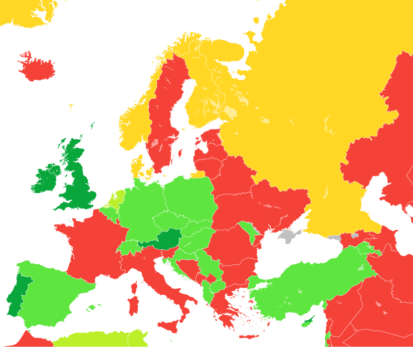
English: A map showing the level of Freedom of Panorama (as seen from the Wikimedia Commons standpoint) in the countries of Europe as well as parts of Western Asia and North Africa
Español: Mapa que ilustra las categorías de la libertad de panorama (desde la perpectiva de Wikimedia Commons) en los países europeos.
Français : Carte montrant le niveau liberté de Panorama (du point de vue de Wikimedia Commons) dans les pays d'Europe.
Italiano: Mappa che illustra la situazione della c.d. libertà di panorama (dal punto di vista di Wikimedia Commons) nei Paesi europei.
日本語: ヨーロッパ諸国の風景の自由 (英語版) (ウィキメディア・コモンズの見解による) の程度。
Nederlands: Kaart tonende het niveau van de panoramavrijheid (vanuit het Wikimedia Commons oogpunt) van de Europese landen.
Tagalog: Isang mapa na nagpapakita ng mga antas ng kalayaan sa panorama (sang-ayon sa pananaw ng Wikimedia Commons) sa mga bansang Europeo.
中文:一張地圖,顯示了歐洲國家的全景自由(從維基共享資源的角度來看)。
NL: Public interiors are OK, but schools, opera buildings, entrance halls of businesses, and museums are not public places for the purpose of Dutch law, while railway stations are.
OK, including public interiors
OK
OK for buildings only
Not OK (Note: this is from the Wikimedia Commons standpoint, so includes countries with non-commercial FOP)
Inconclusive or unknown (only Andorra, San Marino, Monaco, Crimea, and Sweden are marked as "Inconclusive or unknown") |
| Tælmearc | / 20 Eastermonað 2010, 16:49 (UTC) (original upload date) |
| Fruma |
This file was derived from: Blank map of Europe cropped.svg |
| Dædfruma |
|
| Other versions |
|
| SVG genesis |
.png)
.svg)


.svg)
Leaf:
I, the copyright holder of this work, hereby publish it under the following license:
This file is licensed under the Creative Commons Attribution-Share Alike 3.0 Unported license.
- Þu most:
- bryttian – to copy, distribute and transmit the work
- to remix – andwendan þæt weorc
- Under the following conditions:
- hlígung – You must give appropriate credit, provide a link to the license, and indicate if changes were made. You may do so in any reasonable manner, but not in any way that suggests the licensor endorses you or your use.
- Efenlice bryttiendlic – Gif þu andwende þis weorc to ohte, þu scleat bryttian þæt andwendede weorc synderlice mid þære ilcan oþþe gelicre leafe swilcre þis brycþ.
Original upload log
This image is a derivative work of the following images:
- File:Blank map of Europe cropped.svg licensed with Cc-by-sa-2.5
- 2010-04-20T15:38:55Z Quibik 645x690 (266750 Bytes) Serbia had a wrong ISO code.
- 2010-04-20T14:50:17Z Quibik 645x690 (266733 Bytes) RSVG's rendering failed, trying to fix
- 2010-04-20T14:45:48Z Quibik 645x690 (264475 Bytes) further cleanup
- 2009-04-30T19:51:36Z Insuranze 645x690 (269667 Bytes) code cleanup
- 2007-06-07T22:58:16Z Revolus 645x690 (540660 Bytes) {{Information | Description=Cropped version of [[:Image:Blank map of Europe.svg|Blank map of Europe.svg]] as descriped by its author. {{en|A blank Map of Europe in SVG format. Every country has an id which is its ISO-3116-1-
Uploaded with derivativeFX
Ymelan stær
Swing dæg/tide mid mys to seonne þa ymelan swa heo wæs on þære tide geywed.
| Dæg/Tid | Metungincel | Micelnesse gemetu | Brucend | Ymbspræc | |
|---|---|---|---|---|---|
| nu | 18:45, 4 Þrimilcemonað 2024 | | 828 × 696 (700 KB) | ToprakM | updated Northern Cyprus |
| 15:51, 21 Winterfylleð 2023 |  | 828 × 696 (700 KB) | Golden | update Artsakh | |
| 17:15, 13 Solmonaþ 2023 |  | 828 × 696 (704 KB) | TilmannR | Reverted to previous version. Major changes should be discussed and more carefully planned. | |
| 15:28, 13 Solmonaþ 2023 |  | 828 × 696 (716 KB) | Amitchell125 | colours replaced to suit people who are colour-blind | |
| 15:38, 17 Eastermonað 2022 |  | 828 × 696 (704 KB) | Saippuakauppias | Crimea grey, cf. Discussion | |
| 10:12, 26 Winterfylleð 2021 |  | 828 × 696 (704 KB) | Brateevsky | Smaller map with Kazakhstan and Caucasus states | |
| 06:44, 26 Winterfylleð 2021 |  | 1,078 × 697 (704 KB) | Brateevsky | Reverted to version as of 07:03, 4 September 2021 (UTC): Kazakhstan and Azerbaijan are European countries | |
| 09:40, 9 Winterfylleð 2021 |  | 593 × 606 (704 KB) | Chubit | ... | |
| 07:03, 4 Haligmonað 2021 |  | 1,078 × 697 (704 KB) | Chubit | Algeria and Tunisia to grass green | |
| 05:02, 25 Weodmonað 2021 |  | 593 × 606 (704 KB) | Chubit | Adjust the border |
Biliþbendas
Þǣr sind nāne trametas þe bindaþ tō þissum biliðe.
Ymelan eormen nytt
Þas wiki brucaþ þissa ymelena:
- Nytt on az.wikipedia.org
- Nytt on ca.wikipedia.org
- Nytt on de.wikipedia.org
- Nytt on de.wikivoyage.org
- Nytt on dk.wikimedia.org
- Nytt on en.wikipedia.org
- Nytt on eo.wikipedia.org
- Nytt on es.wikipedia.org
- Nytt on ee.wikimedia.org
- Nytt on fa.wikipedia.org
- Nytt on fr.wikipedia.org
- Nytt on ga.wikipedia.org
- Nytt on gl.wikipedia.org
- Nytt on he.wikipedia.org
- Nytt on hr.wikipedia.org
- Nytt on ja.wikipedia.org
View more global usage of this file.