
Ymele:Zealandia topography.jpg

Micelness þisre forebysene: 516 be 600 dotta. Oðra metinga brædo: 206 be 240 dotta | 413 be 480 dotta | 661 be 768 dotta | 881 be 1,024 dotta | 1,391 be 1,617 dotta.
Frumlicu ymele (1,391 × 1,617 pixela, ymelan micelness: 1.34 MB, MIME cynn: image/jpeg)
Scortness
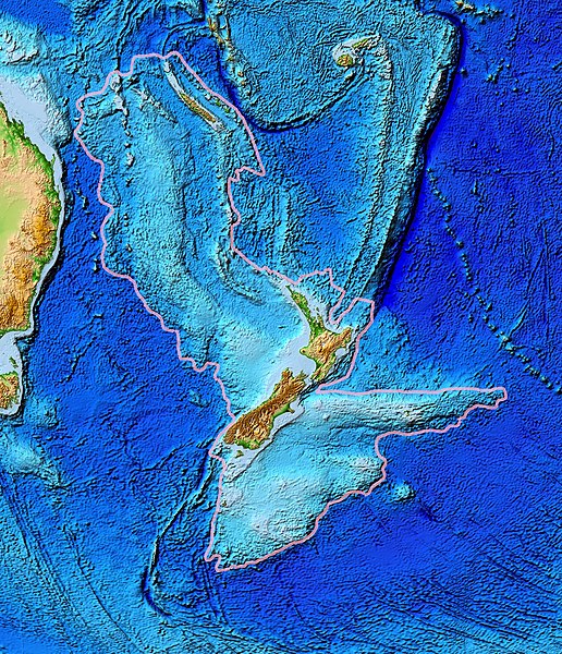
| Towritenness | Topographical map of the Zealandia continent. |
| Tælmearc | |
| Fruma | Ultimate source: ETOPO2v2, a digital database of seafloor and land elevations. Actually cropped from Image:Pacific_elevation.jpg. |
| Dædfruma | World Data Center for Geophysics & Marine Geology (Boulder, CO), National Geophysical Data Center, NOAA |
| Leaf (Eftnytt þisse ymelan) |
NOAA, public domain |
| Other versions | Image:Pacific_elevation.jpg, here cropped to focus on Zealandia. |
Leaf:
This image is in the public domain because it contains materials that originally came from the U.S. National Oceanic and Atmospheric Administration, taken or made as part of an employee's official duties.
|
Ymelan stær
Swing dæg/tide mid mys to seonne þa ymelan swa heo wæs on þære tide geywed.
| Dæg/Tid | Metungincel | Micelnesse gemetu | Brucend | Ymbspræc | |
|---|---|---|---|---|---|
| nu | 13:24, 28 Hreðmonað 2017 | | 1,391 × 1,617 (1.34 MB) | Bogomolov.PL | continent limits with pink |
| 01:44, 13 Hreðmonað 2007 |  | 573 × 677 (143 KB) | Avenue | == Summary == {{Information |Description=Topographical map of the Zealandia continent. |Source=Source: [http://www.ngdc.noaa.gov/mgg/image/2minrelief.html]. Actually cropped from Image:Pacific_elevation.jpg. |Date=June 2006 |Permissio |
Biliþbendas
Þā folgendan trametas bindaþ tō þissum biliðe:
Ymelan eormen nytt
Þas wiki brucaþ þissa ymelena:
- Nytt on af.wikipedia.org
- Nytt on ar.wikipedia.org
- Nytt on ast.wikipedia.org
- Nytt on az.wikipedia.org
- Nytt on bg.wikipedia.org
- Nytt on bn.wikipedia.org
- Nytt on ca.wikipedia.org
- Nytt on el.wikipedia.org
- Nytt on en.wikipedia.org
- Nytt on eo.wikipedia.org
- Nytt on es.wikipedia.org
- Nytt on et.wikipedia.org
- Nytt on eu.wikipedia.org
- Nytt on fa.wikipedia.org
- Nytt on fi.wikipedia.org
- Nytt on fr.wikipedia.org
- Nytt on gl.wikipedia.org
- Nytt on he.wikipedia.org
- Nytt on hi.wikipedia.org
- Nytt on hr.wikipedia.org
- Nytt on hu.wikipedia.org
- Nytt on hy.wikipedia.org
- Nytt on ia.wikipedia.org
- Nytt on id.wikipedia.org
- Nytt on incubator.wikimedia.org
- Nytt on is.wikipedia.org
- Nytt on it.wikipedia.org
- Nytt on ja.wikipedia.org
- Nytt on ka.wikipedia.org
- Nytt on kk.wikipedia.org
- Nytt on ko.wikipedia.org
- Nytt on li.wikipedia.org
- Nytt on lt.wikipedia.org
View more global usage of this file.