
Ymele:Yugoslavia location map.svg

Size of this PNG preview of this SVG file: 450 be 521 dotta. Oðra metinga brædo: 207 be 240 dotta | 415 be 480 dotta | 663 be 768 dotta | 884 be 1,024 dotta | 1,769 be 2,048 dotta.
Frumlicu ymele (SVG ymele, rihte 450 × 521 pixela, ymelan micelness: 762 KB)
Scortness
| Towritenness |
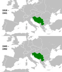
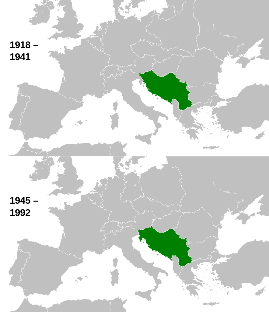
English: This is a map of the evolution of Yugoslavia from 1918 to 1992. |
| Tælmearc | |
| Fruma |
This file was derived from: |
| Dædfruma |
|

.svg)
Leaf:
I, the copyright holder of this work, hereby publish it under the following license:
This file is licensed under the Creative Commons Attribution-Share Alike 3.0 Unported license.
- Þu most:
- bryttian – to copy, distribute and transmit the work
- to remix – andwendan þæt weorc
- Under the following conditions:
- hlígung – You must give appropriate credit, provide a link to the license, and indicate if changes were made. You may do so in any reasonable manner, but not in any way that suggests the licensor endorses you or your use.
- Efenlice bryttiendlic – Gif þu andwende þis weorc to ohte, þu scleat bryttian þæt andwendede weorc synderlice mid þære ilcan oþþe gelicre leafe swilcre þis brycþ.
Original upload log
This image is a derivative work of the following images:
- File:History_of_Yugoslavia.svg licensed with Cc-by-sa-3.0
Uploaded with derivativeFX
Ymelan stær
Swing dæg/tide mid mys to seonne þa ymelan swa heo wæs on þære tide geywed.
| Dæg/Tid | Metungincel | Micelnesse gemetu | Brucend | Ymbspræc | |
|---|---|---|---|---|---|
| nu | 10:01, 12 Weodmonað 2013 | | 450 × 521 (762 KB) | Alphathon | Fixed Hungarian pre-1941 border |
| 14:07, 10 Eastermonað 2013 |  | 450 × 521 (758 KB) | Alphathon | == {{int:filedesc}} == {{Information |Description={{en|1=This is a map of the evolution of Yugoslavia from 1918 to 1992.}} |date=2013-03-25 15:13:51 |Source={{Derived from|History_of_Yugoslavia.svg|Blank_map_of_Europe_1929-1938.svg|Blank_map_of_Europe_... |
Biliþbendas
Þā folgendan trametas bindaþ tō þissum biliðe:
Ymelan eormen nytt
Þas wiki brucaþ þissa ymelena:
- Nytt on am.wikipedia.org
- Nytt on ar.wikipedia.org
- Nytt on arz.wikipedia.org
- Nytt on ast.wikipedia.org
- Nytt on ba.wikipedia.org
- Nytt on bn.wikipedia.org
- Nytt on ca.wikipedia.org
- Nytt on csb.wikipedia.org
- Nytt on el.wikipedia.org
- Nytt on en.wikipedia.org
- Nytt on es.wikipedia.org
- Nytt on et.wikipedia.org
- Nytt on eu.wikipedia.org
- Nytt on fa.wikipedia.org
- Nytt on fi.wikipedia.org
- Nytt on ga.wikipedia.org
- Nytt on gd.wikipedia.org
- Nytt on gl.wikipedia.org
- Nytt on hy.wikipedia.org
- Nytt on ia.wikipedia.org
- Nytt on id.wikipedia.org
- Nytt on ie.wikipedia.org
- Nytt on kk.wikipedia.org
- Nytt on km.wikipedia.org
- Nytt on ko.wikipedia.org
- Nytt on ku.wikipedia.org
- Nytt on li.wikipedia.org
- Nytt on lt.wikipedia.org
- Nytt on ms.wikipedia.org
- Nytt on mwl.wikipedia.org
- Nytt on my.wikipedia.org
- Nytt on mzn.wikipedia.org
- Nytt on nds-nl.wikipedia.org
- Nytt on ne.wikipedia.org
- Nytt on no.wikipedia.org
- Nytt on pl.wikipedia.org
- Nytt on pl.wiktionary.org
- Nytt on ps.wikipedia.org
- Nytt on pt.wikipedia.org
- Nytt on simple.wikipedia.org
- Nytt on si.wikipedia.org
- Nytt on sk.wikipedia.org
- Nytt on sl.wikiquote.org
View more global usage of this file.