
Ymele:Winchester cathedral - geograph.org.uk - 1628919.jpg
Nænig mare micelness nis brucendlicu.
Winchester_cathedral_-_geograph.org.uk_-_1628919.jpg (640 × 428 pixela, ymelan micelness: 188 KB, MIME cynn: image/jpeg)
Scortness
| Towritenness |
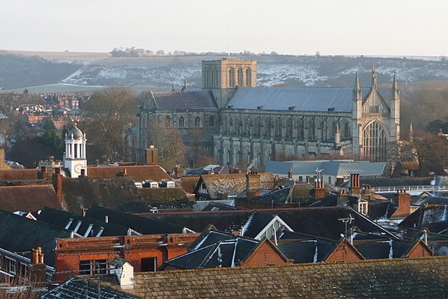
English: Winchester cathedral Taken from the 2nd floor of Hampshire County Council's refurbished offices at E2 Court. The cathedral squats in the valley of the River Itchen, but none the less dominates the city. Started in 1079 by Bishop Walklin, it was consecrated in 1093. The tower fell down in 1107 (thought to be bad luck caused by the burial of the unpopular King William 2nd (Rufus) here in 1100) and was never rebuilt. The nave (this end between the West window and the tower) is the second longest in Europe after St. Peter's in Rome. |
| Tælmearc | |
| Fruma | From geograph.org.uk |
| Dædfruma | Graham Horn |
| Hligung (required by the license) | Graham Horn / Winchester cathedral / |
| Camera location | | View this and other nearby images on: OpenStreetMap |
|---|
_heading:135.00&language=ang)
| Object location | | View this and other nearby images on: OpenStreetMap |
|---|
_heading:135.00&language=ang)
Leaf:

|
This image was taken from the Geograph project collection. See this photograph's page on the Geograph website for the photographer's contact details. The copyright on this image is owned by Graham Horn and is licensed for reuse under the Creative Commons Attribution-ShareAlike 2.0 license.
|
This file is licensed under the Creative Commons Attribution-Share Alike 2.0 Generic license.
Hligung: Graham Horn
- Þu most:
- bryttian – to copy, distribute and transmit the work
- to remix – andwendan þæt weorc
- Under the following conditions:
- hlígung – You must give appropriate credit, provide a link to the license, and indicate if changes were made. You may do so in any reasonable manner, but not in any way that suggests the licensor endorses you or your use.
- Efenlice bryttiendlic – Gif þu andwende þis weorc to ohte, þu scleat bryttian þæt andwendede weorc synderlice mid þære ilcan oþþe gelicre leafe swilcre þis brycþ.
Ymelan stær
Swing dæg/tide mid mys to seonne þa ymelan swa heo wæs on þære tide geywed.
| Dæg/Tid | Metungincel | Micelnesse gemetu | Brucend | Ymbspræc | |
|---|---|---|---|---|---|
| nu | 14:55, 4 Hreðmonað 2011 | | 640 × 428 (188 KB) | GeographBot | == {{int:filedesc}} == {{Information |description={{en|1=Winchester cathedral Taken from the 2nd floor of Hampshire County Council's refurbished offices at E2 Court. The cathedral squats in the valley of the River Itchen, but none the less dominates the |
Biliþbendas
Þā folgendan trametas bindaþ tō þissum biliðe:
Ymelan eormen nytt
Þas wiki brucaþ þissa ymelena:
- Nytt on az.wikipedia.org
- Nytt on en.wikipedia.org
- Nytt on fi.wikipedia.org
- Nytt on is.wikipedia.org
- Nytt on lv.wikipedia.org
- Nytt on vi.wikipedia.org
- Nytt on war.wikipedia.org
- Nytt on wuu.wikipedia.org
- Nytt on zh-min-nan.wikipedia.org