
Ymele:Virginia geographic map-en.svg

Size of this PNG preview of this SVG file: 800 be 439 dotta. Oðra metinga brædo: 320 be 176 dotta | 640 be 352 dotta | 1,024 be 562 dotta | 1,280 be 703 dotta | 2,560 be 1,406 dotta | 3,641 be 2,000 dotta.
Frumlicu ymele (SVG ymele, rihte 3,641 × 2,000 pixela, ymelan micelness: 12.5 MB)
Scortness
| Towritenness |
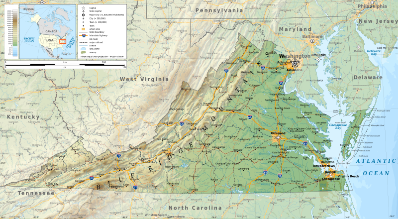
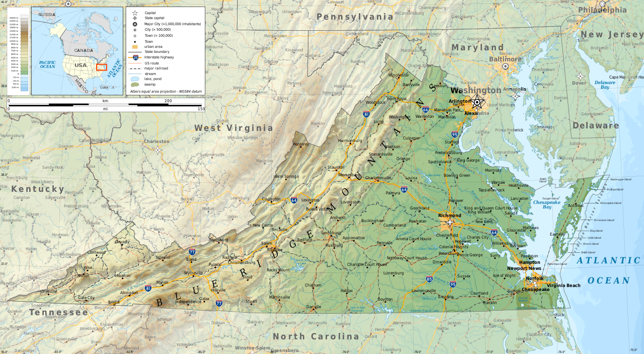
English: Geographic map of Virginia in English. Geographic limits of the map:
|
| Tælmearc | |
| Fruma |
Agen weorc
|
| Dædfruma | Ikonact |
| Leaf (Eftnytt þisse ymelan) |
Any use of this map is subject of the license(s) stated below with the condition that you credit (Wikimedia Commons user: Ikonact) as the author . A message with a reply address would also be greatly appreciated. |

|
This SVG file contains embedded text that can be translated into your language, using any capable SVG editor, text editor or the SVG Translate tool. For more information see: About translating SVG files. |
Leaf:
I, the copyright holder of this work, hereby publish it under the following license:
This file is licensed under the Creative Commons Attribution-Share Alike 4.0 International license.
- Þu most:
- bryttian – to copy, distribute and transmit the work
- to remix – andwendan þæt weorc
- Under the following conditions:
- hlígung – You must give appropriate credit, provide a link to the license, and indicate if changes were made. You may do so in any reasonable manner, but not in any way that suggests the licensor endorses you or your use.
- Efenlice bryttiendlic – Gif þu andwende þis weorc to ohte, þu scleat bryttian þæt andwendede weorc synderlice mid þære ilcan oþþe gelicre leafe swilcre þis brycþ.
Ymelan stær
Swing dæg/tide mid mys to seonne þa ymelan swa heo wæs on þære tide geywed.
| Dæg/Tid | Metungincel | Micelnesse gemetu | Brucend | Ymbspræc | |
|---|---|---|---|---|---|
| nu | 10:08, 16 Haligmonað 2019 | | 3,641 × 2,000 (12.5 MB) | Ikonact | valid svg |
| 08:37, 16 Haligmonað 2019 |  | 3,641 × 2,000 (12.59 MB) | Ikonact | swamp pattern removed... librsvg bug with handling patterns at small sized pictures | |
| 22:08, 15 Haligmonað 2019 |  | 3,641 × 2,000 (13.38 MB) | Ikonact | some font issues | |
| 21:48, 15 Haligmonað 2019 |  | 3,641 × 2,000 (13.38 MB) | Ikonact | names added, size changed | |
| 22:08, 13 Haligmonað 2019 |  | 5,461 × 3,000 (12.2 MB) | Ikonact | =={{int:filedesc}}== {{Information |description={{en|1=Geographic map of Virginia. Geographic limits of the map:}} *N: 39.98° N *S: 36.00° N *W: 83.75° W *E: 74.80° W Albers equal area projection; WGS 84 datum |date=2019-09-14 |source={{own}} *Sources of data:<br/> **Topography: ETOPO1 (public domain);<br/> **Public domain data provided by the National Atlas of the United States of America;<br/> *Tool:<br/> **The map is created with Octave scripts developed by Ikonact |author... |
Biliþbendas
Þā folgendan trametas bindaþ tō þissum biliðe:
Ymelan eormen nytt
Þas wiki brucaþ þissa ymelena:
- Nytt on be.wikipedia.org
- Nytt on bg.wikipedia.org
- Nytt on ca.wikipedia.org
- Nytt on en.wikipedia.org
- Nytt on ga.wikipedia.org
- Nytt on gl.wikipedia.org
- Nytt on hu.wikipedia.org
- Nytt on hy.wikipedia.org
- Nytt on lt.wikipedia.org
- Nytt on mhr.wikipedia.org
- Nytt on os.wikipedia.org
- Nytt on ru.wikipedia.org
- Nytt on tg.wikipedia.org
- Nytt on tt.wikipedia.org
- Nytt on www.wikidata.org