
Ymele:New York state geographic map-en.svg

Size of this PNG preview of this SVG file: 800 be 569 dotta. Oðra metinga brædo: 320 be 228 dotta | 640 be 455 dotta | 1,024 be 729 dotta | 1,280 be 911 dotta | 2,560 be 1,821 dotta | 2,811 be 2,000 dotta.
Frumlicu ymele (SVG ymele, rihte 2,811 × 2,000 pixela, ymelan micelness: 18.34 MB)
Scortness
| Description |
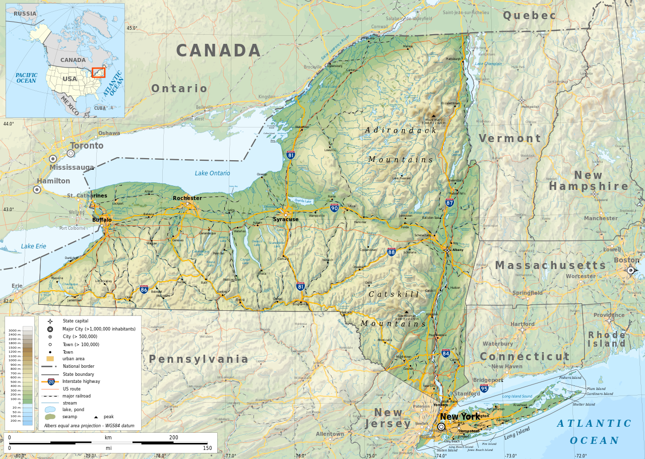
English: Geographic map of New York state in English. Geographic limits of the map:
|
| Tælmearc | |
| Fruma |
Agen weorc
|
| Creator | |
| Leaf (Eftnytt þisse ymelan) |
Any use of this map is subject of the license(s) stated below with the condition that you credit (Wikimedia Commons user: Ikonact) as the author . A message with a reply address would also be greatly appreciated. |
| Georeferencing | If inappropriate please set warp_status = skip to hide. |
|

|
This SVG file contains embedded text that can be translated into your language, using any capable SVG editor, text editor or the SVG Translate tool. For more information see: About translating SVG files. |
Leaf:
| This work contains information from OpenStreetMap, which is made available under the Open Database License (ODbL).
The ODbL does not require any particular license for maps produced from ODbL data. Prior to 1 August 2020, map tiles produced by the OpenStreetMap Foundation were licensed under the CC-BY-SA-2.0 license. Maps produced by other people may be subject to other licences. |
I, the copyright holder of this work, hereby publish it under the following license:
This file is licensed under the Creative Commons Attribution-Share Alike 4.0 International license.
- Þu most:
- bryttian – to copy, distribute and transmit the work
- to remix – andwendan þæt weorc
- Under the following conditions:
- hlígung – You must give appropriate credit, provide a link to the license, and indicate if changes were made. You may do so in any reasonable manner, but not in any way that suggests the licensor endorses you or your use.
- Efenlice bryttiendlic – Gif þu andwende þis weorc to ohte, þu scleat bryttian þæt andwendede weorc synderlice mid þære ilcan oþþe gelicre leafe swilcre þis brycþ.
Ymelan stær
Swing dæg/tide mid mys to seonne þa ymelan swa heo wæs on þære tide geywed.
| Dæg/Tid | Metungincel | Micelnesse gemetu | Brucend | Ymbspræc | |
|---|---|---|---|---|---|
| nu | 12:15, 2 Blotmonað 2023 | | 2,811 × 2,000 (18.34 MB) | Ikonact | corrected some typos in names // Editing SVG source code using c:User:Rillke/SVGedit.js |
| 10:22, 14 Winterfylleð 2019 |  | 2,811 × 2,000 (18.41 MB) | Ikonact | better dealing with fall back font | |
| 21:19, 12 Winterfylleð 2019 |  | 2,811 × 2,000 (20.53 MB) | Ikonact | + fall back font, more towns and islands, provinces | |
| 23:33, 11 Winterfylleð 2019 |  | 2,811 × 2,000 (20.47 MB) | Ikonact | error corrected | |
| 23:23, 11 Winterfylleð 2019 |  | 2,811 × 2,000 (20.47 MB) | Ikonact | river and lake names added | |
| 21:58, 8 Winterfylleð 2019 |  | 2,811 × 2,000 (20.33 MB) | Ikonact | some improvements, roads and cities in Canada | |
| 07:40, 22 Haligmonað 2019 |  | 2,811 × 2,000 (14.39 MB) | Ikonact | small corrections | |
| 20:49, 21 Haligmonað 2019 |  | 2,811 × 2,000 (14.39 MB) | Ikonact | + road names | |
| 20:23, 21 Haligmonað 2019 |  | 2,811 × 2,000 (14.31 MB) | Ikonact | +names | |
| 22:01, 20 Haligmonað 2019 |  | 2,811 × 2,000 (15.37 MB) | Ikonact | == {{int:filedesc}} == {{Information |description={{en|1=Geographic map of New York state in English. Geographic limits of the map:}} *N: 45.30° N *S: 40.30° N *W: 80.20° W *E: 71.00° W Albers equal area projection; WGS 84 datum |date=2019-09-21 |source={{own}} *Sources of data:<br/> **Topography: ETOPO1 (public domain);<br/> **Public domain data provided by the National Atlas of the United States of America;<br/> *Tool:<br/> **The map is created with Octave scripts d... |
Biliþbendas
Þā folgendan trametas bindaþ tō þissum biliðe:
Ymelan eormen nytt
Þas wiki brucaþ þissa ymelena:
- Nytt on af.wikipedia.org
- Nytt on az.wikipedia.org
- Nytt on be.wikipedia.org
- Nytt on bg.wikipedia.org
- Nytt on bn.wikipedia.org
- Nytt on ca.wikipedia.org
- Nytt on en.wikipedia.org
- Nytt on eo.wikipedia.org
- Nytt on fr.wikipedia.org
- Nytt on ga.wikipedia.org
- Nytt on gl.wikipedia.org
- Nytt on ha.wikipedia.org
- Nytt on hu.wikipedia.org
- Nytt on hy.wikipedia.org
- Nytt on id.wikipedia.org
- Nytt on lt.wikipedia.org
- Nytt on mhr.wikipedia.org
- Nytt on ml.wikipedia.org
- Nytt on os.wikipedia.org
- Nytt on pcd.wikipedia.org
- Nytt on pl.wikipedia.org
- Nytt on sh.wikipedia.org
- Nytt on tg.wikipedia.org
- Nytt on tr.wikipedia.org
- Nytt on tt.wikipedia.org
- Nytt on uk.wikipedia.org
- Nytt on www.wikidata.org