
Ymele:Nauru satellite.jpg
Micelness þisre forebysene: 544 be 599 dotta. Oðra metinga brædo: 218 be 240 dotta | 436 be 480 dotta | 1,021 be 1,125 dotta.
Frumlicu ymele (1,021 × 1,125 pixela, ymelan micelness: 326 KB, MIME cynn: image/jpeg)
|
Scortness
| Towritenness |
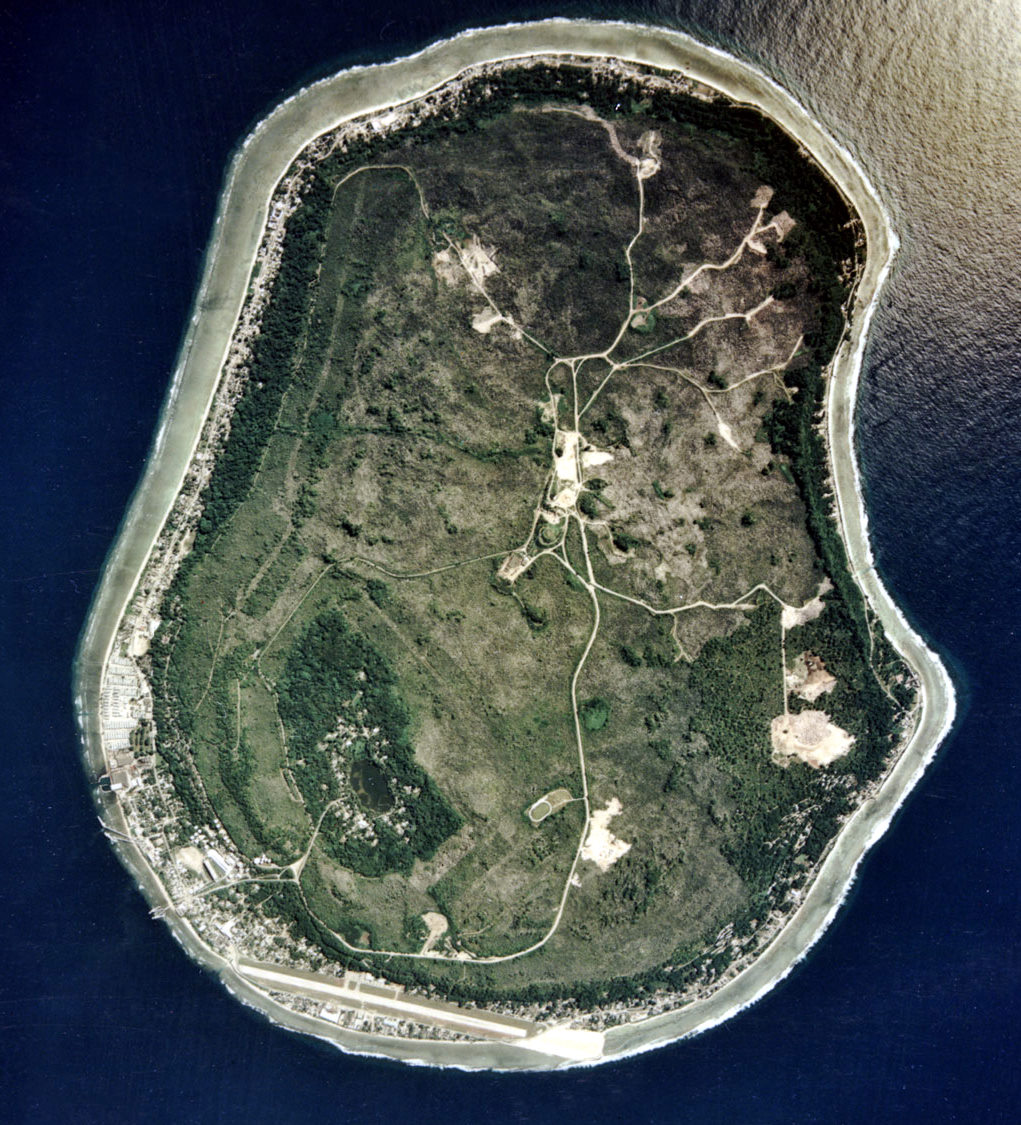
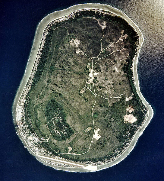
English: Nauru satellite picture |
| Tælmearc | |
| Fruma | Image Library. |
| Dædfruma | ARM |
Leaf:
This photograph was produced by the Atmospheric Radiation Measurement Program.
Their site states:
|
| Annotations | This image is annotated: View the annotations at Commons |
Ymelan stær
Swing dæg/tide mid mys to seonne þa ymelan swa heo wæs on þære tide geywed.
| Dæg/Tid | Metungincel | Micelnesse gemetu | Brucend | Ymbspræc | |
|---|---|---|---|---|---|
| nu | 13:51, 17 Eastermonað 2010 | | 1,021 × 1,125 (326 KB) | Kleinstein95 | cropped |
| 14:25, 5 Þrimilcemonað 2005 |  | 1,115 × 1,217 (339 KB) | Jon Harald Søby | Nauru satellite photo from [http://arm.gov ARM.gov] {{PD-USGov}} Category:Nauru |
Biliþbendas
Þā folgendan trametas bindaþ tō þissum biliðe:
Ymelan eormen nytt
Þas wiki brucaþ þissa ymelena:
- Nytt on af.wikipedia.org
- Nytt on als.wikipedia.org
- Nytt on ami.wikipedia.org
- Nytt on ar.wikipedia.org
- Nytt on ast.wikipedia.org
- Nytt on azb.wikipedia.org
- Nytt on az.wikipedia.org
- Nytt on be.wikipedia.org
- Nytt on bs.wikipedia.org
- Nytt on ca.wikipedia.org
- Nytt on cs.wikipedia.org
- Nytt on cy.wikipedia.org
- Nytt on da.wikipedia.org
- Nytt on de.wikipedia.org
- Nytt on de.wiktionary.org
- Nytt on el.wikipedia.org
- Nytt on en.wikipedia.org
- Nauru
- Geography of Nauru
- Environmental disaster
- User talk:Jouster
- User:Amerika/Tampabaysports
- Wikipedia:Today's featured article/July 2006
- Wikipedia:Today's featured article/July 8, 2006
- User talk:Nick-D/Awards
- Geology of Nauru
- Outline of Nauru
- User talk:Nick-D/Archive 8
- Wikipedia:Featured picture candidates/January-2013
- Wikipedia:Featured picture candidates/Satellite view of Nauru
- User:Googletheninja/sandbox
- Nytt on en.wikinews.org
- Nytt on en.wikiversity.org
- Nytt on eo.wikipedia.org
- Nytt on es.wikipedia.org
View more global usage of this file.