
Ymele:Map of Rhode Island NA.png
Micelness þisre forebysene: 776 be 600 dotta. Oðra metinga brædo: 311 be 240 dotta | 621 be 480 dotta | 994 be 768 dotta | 1,280 be 989 dotta | 2,122 be 1,640 dotta.
Frumlicu ymele (2,122 × 1,640 pixela, ymelan micelness: 822 KB, MIME cynn: image/png)
Scortness
| Towritenness |
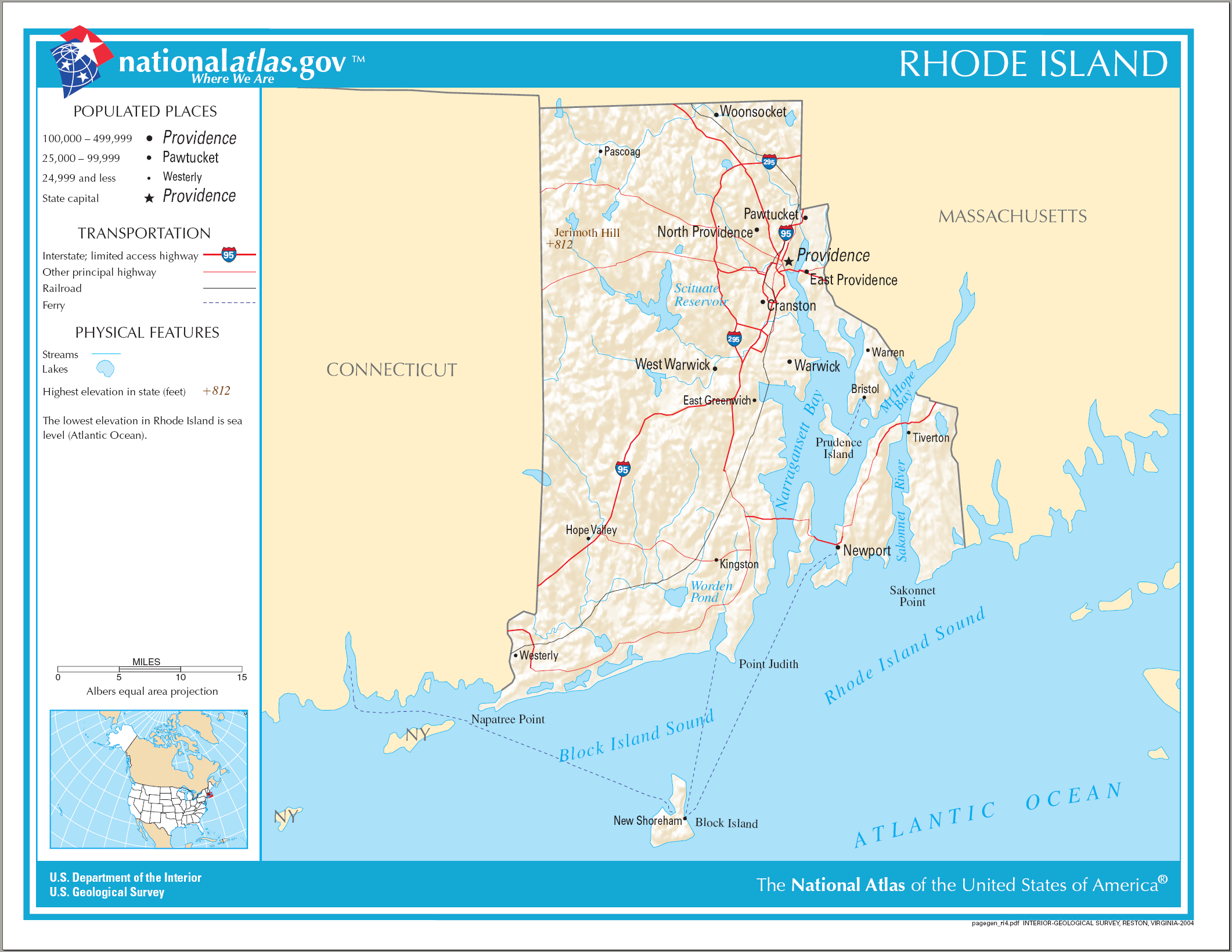
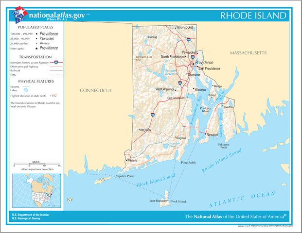
English: National Atlas map of Rhode Island. |
| Tælmearc | |
| Fruma | National Atlas |
| Dædfruma |
Leaf:
This map was obtained from an edition of the National Atlas of the United States. Like almost all works of the U.S. federal government, works from the National Atlas are in the public domain in the United States.
Online access: NationalAtlas.gov | 1970 print edition: Library of Congress, Perry-Castañeda Library
|
Ymelan stær
Swing dæg/tide mid mys to seonne þa ymelan swa heo wæs on þære tide geywed.
| Dæg/Tid | Metungincel | Micelnesse gemetu | Brucend | Ymbspræc | |
|---|---|---|---|---|---|
| nu | 14:16, 17 Eastermonað 2015 | | 2,122 × 1,640 (822 KB) | RokerHRO | optipng -o7 -i0 → 18.34% decrease |
| 08:22, 15 Weodmonað 2006 |  | 2,122 × 1,640 (1,007 KB) | Huebi~commonswiki | {{Information| |Description=Map of Rhode Island |Source=[http://www.nationalatlas.gov National Atlas] }} Category:Maps of the United States Category:Maps of Rhode Island {{PD-USGov-Atlas}} |
Biliþbendas
Þā folgendan trametas bindaþ tō þissum biliðe:
Ymelan eormen nytt
Þas wiki brucaþ þissa ymelena:
- Nytt on be.wikipedia.org
- Nytt on ca.wikipedia.org
- Nytt on de.wikipedia.org
- Nytt on en.wikipedia.org
- Nytt on fi.wikipedia.org
- Nytt on ga.wikipedia.org
- Nytt on gl.wikipedia.org
- Nytt on hu.wikipedia.org
- Nytt on hy.wikipedia.org
- Nytt on ja.wikipedia.org
- Nytt on ko.wikipedia.org
- Nytt on lt.wikipedia.org
- Nytt on mhr.wikipedia.org
- Nytt on mr.wikipedia.org
- Nytt on os.wikipedia.org
- Nytt on sw.wikipedia.org
- Nytt on tg.wikipedia.org
- Nytt on tt.wikipedia.org
- Nytt on www.wikidata.org
- Nytt on zea.wikipedia.org