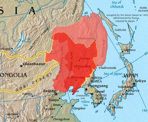
Ymele:Manchuria.png
Manchuria.png (480 × 395 pixela, ymelan micelness: 440 KB, MIME cynn: image/png)
Ymelan stær
Swing dæg/tide mid mys to seonne þa ymelan swa heo wæs on þære tide geywed.
| Dæg/Tid | Metungincel | Micelnesse gemetu | Brucend | Ymbspræc | |
|---|---|---|---|---|---|
| nu | 09:32, 21 Gēolmōnaþ 2023 |  | 480 × 395 (440 KB) | Kwamikagami | Reverted to version as of 12:53, 21 March 2005 (UTC) -- last good version. Urup is not claimed by Japan. |
| 15:26, 27 Þrimilcemonað 2023 |  | 480 × 395 (443 KB) | Minchuchui | Reverted to version as of 11:36, 19 February 2020 (UTC) | |
| 11:26, 22 Solmonaþ 2020 |  | 480 × 395 (447 KB) | Wwbread | Reverted to version as of 20:27, 11 April 2019 (UTC) | |
| 11:36, 19 Solmonaþ 2020 |  | 480 × 395 (443 KB) | Императоры России | Reverted to version as of 16:48, 19 September 2019 (UTC) | |
| 18:47, 9 Solmonaþ 2020 |  | 480 × 395 (447 KB) | Wwbread | Reverted to version as of 20:27, 11 April 2019 (UTC). See discussion page. | |
| 16:48, 19 Haligmonað 2019 |  | 480 × 395 (443 KB) | Императоры России | Kuye/Sakharin Island (库页岛) isn't included in Manchuria. | |
| 03:54, 13 Haligmonað 2019 |  | 480 × 395 (447 KB) | Spodnikel | Reverted to version as of 20:27, 11 April 2019 (UTC) | |
| 12:14, 4 Haligmonað 2019 |  | 480 × 395 (443 KB) | Императоры России | Reverted to version as of 12:30, 10 July 2018 (UTC) | |
| 20:27, 11 Eastermonað 2019 |  | 480 × 395 (447 KB) | Wwbread | Kuye/Sakharin Island (库页岛) is a part of outer Manchuria. | |
| 12:30, 10 Mædmonað 2018 |  | 480 × 395 (443 KB) | Trecătorul răcit | Contrast |
Biliþbendas
Þǣr sind nāne trametas þe bindaþ tō þissum biliðe.
Ymelan eormen nytt
Þas wiki brucaþ þissa ymelena:
- Nytt on als.wikipedia.org
- Nytt on ar.wikipedia.org
- Nytt on arz.wikipedia.org
- Nytt on ast.wikipedia.org
- Nytt on azb.wikipedia.org
- Nytt on az.wikipedia.org
- Nytt on be-tarask.wikipedia.org
- Nytt on be.wikipedia.org
- Nytt on bg.wikipedia.org
- Nytt on bn.wikipedia.org
- Nytt on br.wikipedia.org
- Nytt on ca.wikipedia.org
- Nytt on cs.wikipedia.org
- Nytt on de.wikipedia.org
- Nytt on dsb.wikipedia.org
- Nytt on el.wikipedia.org
- Nytt on el.wikiversity.org
- Nytt on en.wikipedia.org
- Nytt on en.wikiversity.org
- Nytt on eo.wikipedia.org
- Nytt on es.wikipedia.org
- Nytt on eu.wikipedia.org
- Nytt on fa.wikipedia.org
- Nytt on frr.wikipedia.org
- Nytt on fr.wikipedia.org
- Nytt on ga.wikipedia.org
- Nytt on gl.wikipedia.org
- Nytt on he.wikipedia.org
- Nytt on hi.wikipedia.org
- Nytt on hu.wikipedia.org
View more global usage of this file.


