
Ymele:LocationStHelena.PNG
Nænig mare micelness nis brucendlicu.
LocationStHelena.PNG (465 × 303 pixela, ymelan micelness: 12 KB, MIME cynn: image/png)
Scortness
| Towritenness |
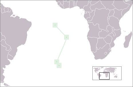
English: Location of the British overseas territory of St. Helena, Ascension und Tristan da Cunha in the Atlantic Ocean |
| Tælmearc | |
| Fruma | Agen weorc |
| Dædfruma | Telim tor |
Leaf:
| I, the copyright holder of this work, release this work into the public domain. This applies worldwide. In some countries this may not be legally possible; if so: I grant anyone the right to use this work for any purpose, without any conditions, unless such conditions are required by law. |
Ymelan stær
Swing dæg/tide mid mys to seonne þa ymelan swa heo wæs on þære tide geywed.
| Dæg/Tid | Metungincel | Micelnesse gemetu | Brucend | Ymbspræc | |
|---|---|---|---|---|---|
| nu | 09:03, 23 Mædmonað 2009 | | 465 × 303 (12 KB) | Telim tor | with frame |
| 08:53, 23 Mædmonað 2009 |  | 465 × 303 (9 KB) | Telim tor | == {{int:filedesc}} == {{Information |Description={{en|Location of the British overseas territory of Saint Helena in the Atlantic Ocean}} |Source={{own}} |Date=2009-07-23 |Author=Telim tor |Permission= |other_versions= }} == {{int:lic |
Biliþbendas
Þǣr sind nāne trametas þe bindaþ tō þissum biliðe.
Ymelan eormen nytt
Þas wiki brucaþ þissa ymelena:
- Nytt on am.wikipedia.org
- Nytt on ar.wikipedia.org
- Nytt on de.wikivoyage.org
- Nytt on en.wikipedia.org
- Nytt on ka.wikipedia.org
- Nytt on pl.wikipedia.org
- Nytt on rw.wikipedia.org
- Nytt on sl.wikipedia.org