
Ymele:LocationSlovenia.png
Nænig mare micelness nis brucendlicu.
LocationSlovenia.png (250 × 115 pixela, ymelan micelness: 6 KB, MIME cynn: image/png)

|
This locator map image could be re-created using vector graphics as an SVG file. This has several advantages; see Commons:Media for cleanup for more information. If an SVG form of this image is available, please upload it and afterwards replace this template with
{{vector version available|new image name}}.
It is recommended to name the SVG file “LocationSlovenia.svg”—then the template Vector version available (or Vva) does not need the new image name parameter. |
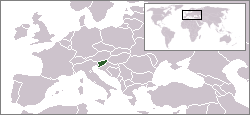
Location map of Slovenia.
Originally created for English Wikipedia by Vardion.
| |
This work has been released into the public domain by its author, Vardion, at the English Ƿikipǣdia project. This applies worldwide. In case this is not legally possible: |
Ymelan stær
Swing dæg/tide mid mys to seonne þa ymelan swa heo wæs on þære tide geywed.
| Dæg/Tid | Metungincel | Micelnesse gemetu | Brucend | Ymbspræc | |
|---|---|---|---|---|---|
| nu | 16:48, 6 Sēremōnaþ 2006 | | 250 × 115 (6 KB) | Rain74 | Montenegro |
| 13:50, 8 Gēolmōnaþ 2004 |  | 250 × 115 (7 KB) | EugeneZelenko | Location map for the Slovenia.<br/>Originally created for English Wikipedia by Vardion.<br/>{{PD}}<br/>Category:Country locator maps |
Biliþbendas
Þā folgendan trametas bindaþ tō þissum biliðe:
Ymelan eormen nytt
Þas wiki brucaþ þissa ymelena:
- Nytt on arc.wikipedia.org
- Nytt on ar.wikinews.org
- Nytt on avk.wikipedia.org
- Nytt on av.wikipedia.org
- Nytt on be-tarask.wikipedia.org
- Nytt on bpy.wikipedia.org
- Nytt on br.wikipedia.org
- Nytt on ca.wikipedia.org
- Nytt on de.wiktionary.org
- Nytt on el.wikivoyage.org
- Nytt on el.wiktionary.org
- Nytt on en.wikipedia.org
- Nytt on en.wikinews.org
- Nytt on en.wikivoyage.org
- Nytt on en.wiktionary.org
- Nytt on es.wikinews.org
- Nytt on eu.wiktionary.org
- Nytt on fiu-vro.wikipedia.org
- Nytt on he.wikivoyage.org
- Nytt on hif.wikipedia.org
- Nytt on ia.wikipedia.org
- Nytt on incubator.wikimedia.org
- Nytt on it.wikivoyage.org
- Nytt on ja.wiktionary.org
- Nytt on jbo.wikipedia.org
- Nytt on jv.wikipedia.org
- Nytt on ka.wikipedia.org
- Nytt on kk.wikipedia.org
- Nytt on ko.wikipedia.org
- Nytt on ky.wikipedia.org
- Nytt on lij.wikipedia.org
- Nytt on lt.wiktionary.org
- Nytt on lv.wiktionary.org
- Nytt on nds.wiktionary.org
View more global usage of this file.