
Ymele:Diaoyutai senkaku.png
Micelness þisre forebysene: 800 be 402 dotta. Oðra metinga brædo: 320 be 161 dotta | 640 be 321 dotta | 1,165 be 585 dotta.
Frumlicu ymele (1,165 × 585 pixela, ymelan micelness: 46 KB, MIME cynn: image/png)

|
This locator map image could be re-created using vector graphics as an SVG file. This has several advantages; see Commons:Media for cleanup for more information. If an SVG form of this image is available, please upload it and afterwards replace this template with
{{vector version available|new image name}}.
It is recommended to name the SVG file “Diaoyutai senkaku.svg”—then the template Vector version available (or Vva) does not need the new image name parameter. |
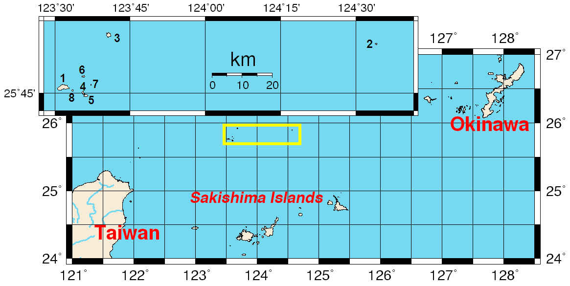
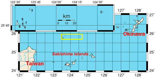
Map of the disputed Diaoyutai/Senkaku Islands.
Map created using the Generic Mapping Tools (GMT).
External link
- GMT archive copy at the Wayback Machine

|
Permission is granted to copy, distribute and/or modify this document under the terms of the GNU Free Documentation License, Version 1.2 or any later version published by the Free Software Foundation; with no Invariant Sections, no Front-Cover Texts, and no Back-Cover Texts. A copy of the license is included in the section entitled GNU Free Documentation License. |
| This file is licensed under the Creative Commons Attribution-Share Alike 3.0 Unported license. | ||
| ||
| This licensing tag was added to this file as part of the GFDL licensing update. |
Ymelan stær
Swing dæg/tide mid mys to seonne þa ymelan swa heo wæs on þære tide geywed.
| Dæg/Tid | Metungincel | Micelnesse gemetu | Brucend | Ymbspræc | |
|---|---|---|---|---|---|
| nu | 09:40, 1 Hreðmonað 2015 | | 1,165 × 585 (46 KB) | Lssrn | rectangle changed into yellow; added name of the island chain below |
| 11:33, 24 Blotmonað 2014 |  | 1,165 × 585 (28 KB) | Garam | Reverted to version as of 03:52, 31 December 2013 | |
| 16:06, 24 Sēremōnaþ 2014 |  | 1,239 × 621 (156 KB) | Azukimame | ||
| 13:06, 24 Sēremōnaþ 2014 |  | 1,239 × 622 (160 KB) | Azukimame | Reverted to version as of 11:30, 7 August 2013 | |
| 03:52, 31 Gēolmōnaþ 2013 |  | 1,165 × 585 (28 KB) | Garam | Reverted to version as of 14:26, 10 October 2012 | |
| 11:30, 7 Weodmonað 2013 |  | 1,239 × 622 (160 KB) | Azukimame | Reverted to version as of 18:02, 29 September 2012 | |
| 14:26, 10 Winterfylleð 2012 |  | 1,165 × 585 (28 KB) | Garam | Reverted to version as of 23:30, 27 October 2006: Okinawa island (x), Okinawa ken (o) | |
| 18:02, 29 Haligmonað 2012 |  | 1,239 × 622 (160 KB) | Azukimame | added some names of island | |
| 23:30, 27 Winterfylleð 2006 |  | 1,165 × 585 (28 KB) | Jjok | added number | |
| 15:52, 17 Mædmonað 2005 |  | 1,160 × 580 (25 KB) | Taichi | Map of the disputed Diaoyutai/Senkaku Islands. Map created using the Generic Mapping Tools (GMT). ==External link== *[http://gmt.soest.hawaii.edu GMT] {{GFDL}} |
Biliþbendas
Þā folgendan trametas bindaþ tō þissum biliðe:
Ymelan eormen nytt
Þas wiki brucaþ þissa ymelena:
- Nytt on af.wikipedia.org
- Nytt on ar.wikipedia.org
- Nytt on az.wikipedia.org
- Nytt on bn.wikipedia.org
- Nytt on ca.wikipedia.org
- Nytt on ceb.wikipedia.org
- Nytt on cy.wikipedia.org
- Nytt on da.wikipedia.org
- Nytt on de.wikipedia.org
- Nytt on en.wikipedia.org
- Nytt on eo.wikipedia.org
- Nytt on es.wikipedia.org
- Nytt on eu.wikipedia.org
- Nytt on fi.wikipedia.org
- Nytt on fr.wikipedia.org
- Nytt on hak.wikipedia.org
- Nytt on hu.wikipedia.org
- Nytt on hy.wikipedia.org
- Nytt on it.wikipedia.org
- Nytt on it.wikinews.org
- Nytt on ja.wikipedia.org
- Nytt on ka.wikipedia.org
- Nytt on ko.wikipedia.org
- Nytt on nl.wikipedia.org
- Nytt on nn.wikipedia.org
- Nytt on no.wikipedia.org
- Nytt on pt.wikipedia.org
- Nytt on ru.wikipedia.org
- Nytt on ru.wikinews.org
- Nytt on sco.wikipedia.org
- Nytt on simple.wikipedia.org
- Nytt on sv.wikipedia.org
- Nytt on ta.wikipedia.org
- Nytt on th.wikipedia.org
- Nytt on ur.wikipedia.org
View more global usage of this file.