
Ymele:Danubemap.png
Nænig mare micelness nis brucendlicu.
Danubemap.png (747 × 480 pixela, ymelan micelness: 601 KB, MIME cynn: image/png)

|
This map image could be re-created using vector graphics as an SVG file. This has several advantages; see Commons:Media for cleanup for more information. If an SVG form of this image is available, please upload it and afterwards replace this template with
{{vector version available|new image name}}.
It is recommended to name the SVG file “Danubemap.svg”—then the template Vector version available (or Vva) does not need the new image name parameter. |
Scortness
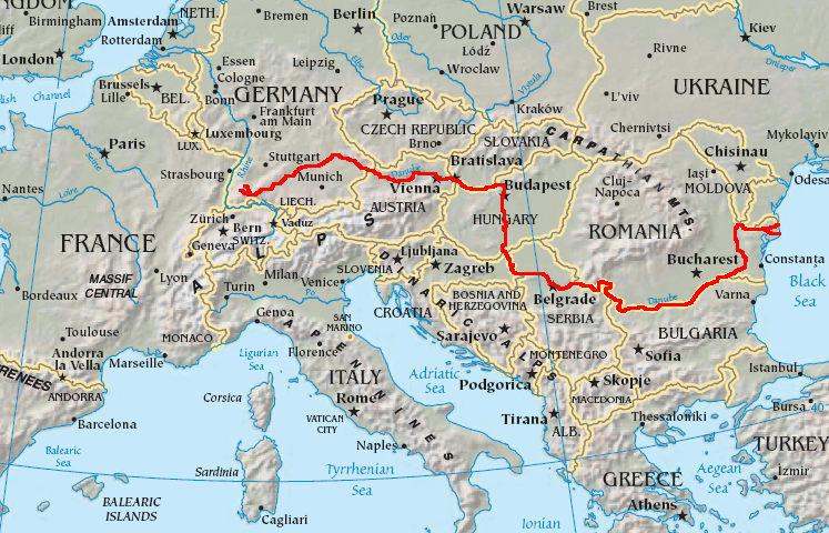
English: Map showing the flow of the Danube River. Uses the map of Europe from the CIA World Factbook.
Leaf:
This image is in the public domain because it contains materials that originally came from the United States Central Intelligence Agency's World Factbook.
|
 |
Ymelan stær
Swing dæg/tide mid mys to seonne þa ymelan swa heo wæs on þære tide geywed.
| Dæg/Tid | Metungincel | Micelnesse gemetu | Brucend | Ymbspræc | |
|---|---|---|---|---|---|
| nu | 05:34, 12 Solmonaþ 2007 | | 747 × 480 (601 KB) | Geologik | Map showing the flow of the Danube River. Uses the map of Europe from the CIA World Factbook. |
Biliþbendas
Þā folgendan trametas bindaþ tō þissum biliðe:
Ymelan eormen nytt
Þas wiki brucaþ þissa ymelena:
- Nytt on ast.wikipedia.org
- Nytt on av.wikipedia.org
- Nytt on azb.wikipedia.org
- Nytt on ban.wikipedia.org
- Nytt on be-tarask.wikipedia.org
- Nytt on bg.wikipedia.org
View more global usage of this file.