
Ymele:Antarctica Farthest Souths.svg

Size of this PNG preview of this SVG file: 532 be 599 dotta. Oðra metinga brædo: 213 be 240 dotta | 426 be 480 dotta | 682 be 768 dotta | 909 be 1,024 dotta | 1,818 be 2,048 dotta | 1,144 be 1,289 dotta.
Frumlicu ymele (SVG ymele, rihte 1,144 × 1,289 pixela, ymelan micelness: 63 KB)
Scortness
| Towritenness |
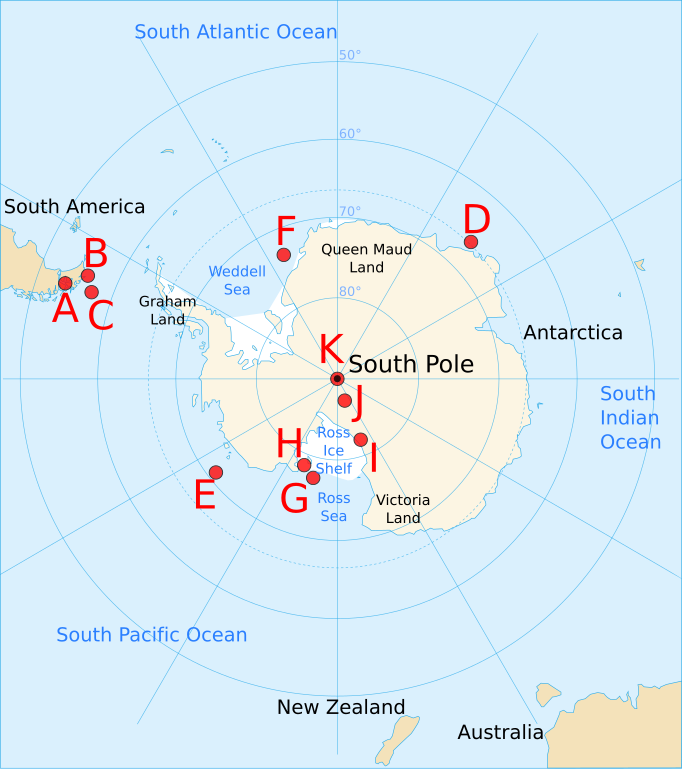
English: Map of Antarctica and the southern hemisphere for the w:Farthest South article, showing farthest south records from 1521 to 1911, as follows:
|
| Tælmearc | |
| Fruma | Based on Image:Antarctica blank.svg, Image:Antarctica Map.png, and Image:Farthest South map.png |
| Dædfruma | Jappalang |
| Other versions |
Image:Farthest South map.png — based on this PNG version
|


This W3C-unspecified vector image was created with Inkscape .
Leaf:
I, the copyright holder of this work, hereby publish it under the following licenses:
This file is licensed under the Creative Commons Attribution-Share Alike 3.0 Unported license.
- Þu most:
- bryttian – to copy, distribute and transmit the work
- to remix – andwendan þæt weorc
- Under the following conditions:
- hlígung – You must give appropriate credit, provide a link to the license, and indicate if changes were made. You may do so in any reasonable manner, but not in any way that suggests the licensor endorses you or your use.
- Efenlice bryttiendlic – Gif þu andwende þis weorc to ohte, þu scleat bryttian þæt andwendede weorc synderlice mid þære ilcan oþþe gelicre leafe swilcre þis brycþ.

|
Permission is granted to copy, distribute and/or modify this document under the terms of the GNU Free Documentation License, Version 1.2 or any later version published by the Free Software Foundation; with no Invariant Sections, no Front-Cover Texts, and no Back-Cover Texts. A copy of the license is included in the section entitled GNU Free Documentation License. |
Þu most ceosan leafe
Ymelan stær
Swing dæg/tide mid mys to seonne þa ymelan swa heo wæs on þære tide geywed.
| Dæg/Tid | Metungincel | Micelnesse gemetu | Brucend | Ymbspræc | |
|---|---|---|---|---|---|
| nu | 12:01, 2 Winterfylleð 2008 | | 1,144 × 1,289 (63 KB) | Jappalang | Corrected some locations (with respect to latitude) and added latitude labels |
| 04:11, 2 Winterfylleð 2008 |  | 1,144 × 1,289 (62 KB) | Jappalang | Corrected size and added labels | |
| 00:50, 2 Winterfylleð 2008 |  | 804 × 804 (52 KB) | Jappalang | {{Information |Description={{en|1=Map of Antarctica and the southern hemisphere for the w:Farthest South article, showing farthest south records from 1521 to 1911, as follows: :A Magellan 54°S, 71°W (approx, - longitude wasn't understood then) :B |
Biliþbendas
Þā folgendan trametas bindaþ tō þissum biliðe:
Ymelan eormen nytt
Þas wiki brucaþ þissa ymelena:
- Nytt on en.wikipedia.org
- Nytt on fr.wikipedia.org
- Nytt on it.wikipedia.org
- Nytt on ja.wikipedia.org
- Nytt on pt.wikipedia.org