
Ymele:Zealandia-Continent map en.svg

Size of this PNG preview of this SVG file: 547 be 599 dotta. Oðra metinga brædo: 219 be 240 dotta | 438 be 480 dotta | 701 be 768 dotta | 935 be 1,024 dotta | 1,870 be 2,048 dotta | 789 be 864 dotta.
Frumlicu ymele (SVG ymele, rihte 789 × 864 pixela, ymelan micelness: 327 KB)

Scortness
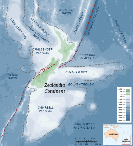
| Towritenness | Map of the Zealandia (continent) |
| Tælmearc | |
| Fruma |
Own work Bathymetry: ETOPO2v2 2min - edited with Inkscape, Land Information New Zealand, Te Ara The Encyclopedia of New Zealand |
| Dædfruma | Alexrk |
| Leaf (Eftnytt þisse ymelan) |
Creative Commons : share alike - attribution required |
| Other versions |
 (topographic) (topographic) |


|
This SVG file contains embedded text that can be translated into your language, using any capable SVG editor, text editor or the SVG Translate tool. For more information see: About translating SVG files. |
Leaf:
I, the copyright holder of this work, hereby publish it under the following license:
This file is licensed under the Creative Commons Attribution-Share Alike 3.0 Unported license.
- Þu most:
- bryttian – to copy, distribute and transmit the work
- to remix – andwendan þæt weorc
- Under the following conditions:
- hlígung – You must give appropriate credit, provide a link to the license, and indicate if changes were made. You may do so in any reasonable manner, but not in any way that suggests the licensor endorses you or your use.
- Efenlice bryttiendlic – Gif þu andwende þis weorc to ohte, þu scleat bryttian þæt andwendede weorc synderlice mid þære ilcan oþþe gelicre leafe swilcre þis brycþ.
Ymelan stær
Swing dæg/tide mid mys to seonne þa ymelan swa heo wæs on þære tide geywed.
| Dæg/Tid | Metungincel | Micelnesse gemetu | Brucend | Ymbspræc | |
|---|---|---|---|---|---|
| nu | 22:37, 19 Mædmonað 2010 | | 789 × 864 (327 KB) | Beao | Removed border. |
| 11:59, 1 Sēremōnaþ 2009 |  | 797 × 871 (375 KB) | Alexrk | Removed Grid | |
| 14:19, 20 Se Æfterra Gēola 2008 |  | 797 × 871 (380 KB) | Alexrk | ||
| 14:10, 20 Se Æfterra Gēola 2008 |  | 797 × 871 (380 KB) | Alexrk | ||
| 16:44, 19 Se Æfterra Gēola 2008 |  | 797 × 871 (380 KB) | Alexrk | ||
| 15:55, 19 Se Æfterra Gēola 2008 |  | 797 × 871 (380 KB) | Alexrk | ||
| 15:52, 19 Se Æfterra Gēola 2008 |  | 1,000 × 1,000 (380 KB) | Alexrk | == Summary == {{Information |Description=Map of the Zealandia Continent |Source=Own work<br/>Bathymetry: ETOPO2v2 2min - vectorized with Inkscape, Land Information New Zealand, Te Ara The Encyclopedia of New Zealand |Date=Jan 2008 |Date=J |
Biliþbendas
Þā folgendan trametas bindaþ tō þissum biliðe:
Ymelan eormen nytt
Þas wiki brucaþ þissa ymelena:
- Nytt on af.wikipedia.org
- Nytt on ast.wikipedia.org
- Nytt on ceb.wikipedia.org
- Nytt on cs.wikipedia.org
- Nytt on de.wikipedia.org
- Nytt on en.wikipedia.org
- Geography of New Zealand
- Hikurangi Trench
- Alpine Fault
- Portal:New Zealand
- Metanephrops challengeri
- User:Epipelagic/sandbox/sources
- Volcanism of New Zealand
- Hikurangi Plateau
- Puysegur Trench
- Talk:Zealandia
- Fishing industry in New Zealand
- Geology of New Zealand
- List of submarine topographical features
- Wikipedia:Reference desk/Archives/Science/2015 May 26
- Nytt on eo.wikipedia.org
- Nytt on es.wikipedia.org
- Nytt on hi.wikipedia.org
- Nytt on hu.wikipedia.org
- Nytt on hy.wikipedia.org
- Nytt on id.wikipedia.org
- Nytt on incubator.wikimedia.org
- Nytt on it.wikipedia.org
- Nytt on ja.wikipedia.org
- Nytt on ka.wikipedia.org
- Nytt on nl.wikipedia.org
View more global usage of this file.