
Ymele:Westbengalimap.png

Micelness þisre forebysene: 668 be 600 dotta. Oðra metinga brædo: 267 be 240 dotta | 535 be 480 dotta | 764 be 686 dotta.
Frumlicu ymele (764 × 686 pixela, ymelan micelness: 278 KB, MIME cynn: image/png)
Scortness
| Towritenness |
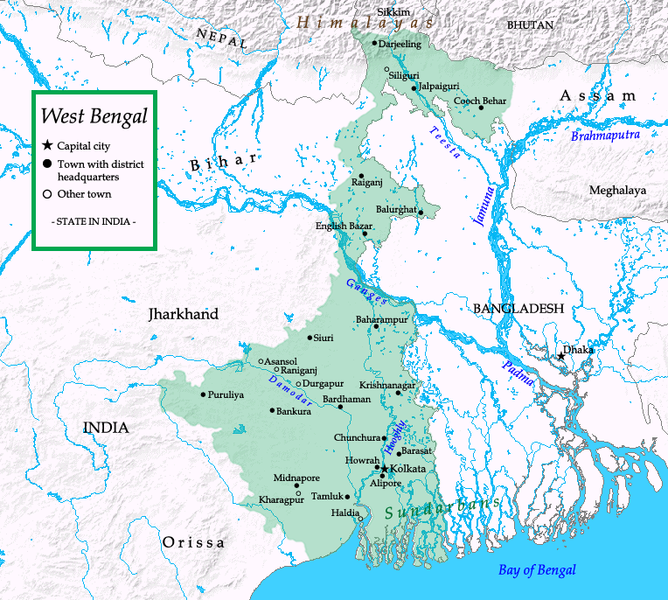
English: Map of West Bengal |
| Tælmearc | |
| Fruma | Self-made; base map from demis.nl, outline map (Image:West Bengal outline map.svg by w:user:Planemad. |
| Dædfruma | Zakuragi |
Leaf:
I, the copyright holder of this work, hereby publish it under the following licenses:
This file is licensed under the Creative Commons Attribution-Share Alike 3.0 Unported, 2.5 Generic, 2.0 Generic and 1.0 Generic license.
- Þu most:
- bryttian – to copy, distribute and transmit the work
- to remix – andwendan þæt weorc
- Under the following conditions:
- hlígung – You must give appropriate credit, provide a link to the license, and indicate if changes were made. You may do so in any reasonable manner, but not in any way that suggests the licensor endorses you or your use.
- Efenlice bryttiendlic – Gif þu andwende þis weorc to ohte, þu scleat bryttian þæt andwendede weorc synderlice mid þære ilcan oþþe gelicre leafe swilcre þis brycþ.

|
Permission is granted to copy, distribute and/or modify this document under the terms of the GNU Free Documentation License, Version 1.2 or any later version published by the Free Software Foundation; with no Invariant Sections, no Front-Cover Texts, and no Back-Cover Texts. A copy of the license is included in the section entitled GNU Free Documentation License. |
Þu most ceosan leafe
This image is in the public domain because it came from the site https://www.demis.nl/products/web-map-server/examples/ and was released by the copyright holder. Permission is granted to copy, distribute and/or modify this map since it is based on free of copyright images from: www.demis.nl. See also approval email on de.wp and its clarification.
|
| This work has been released into the public domain by its copyright holder, www.demis.nl. This applies worldwide. In some countries this may not be legally possible; if so: www.demis.nl grants anyone the right to use this work for any purpose, without any conditions, unless such conditions are required by law.
|
Ymelan stær
Swing dæg/tide mid mys to seonne þa ymelan swa heo wæs on þære tide geywed.
| Dæg/Tid | Metungincel | Micelnesse gemetu | Brucend | Ymbspræc | |
|---|---|---|---|---|---|
| nu | 21:23, 15 Sēremōnaþ 2008 | | 764 × 686 (278 KB) | Tonym88~commonswiki | {{Information |Description={{en|1=Map of West Bengal}} |Source=Self-made; base map from [http://www.demis.nl/wms/mapclip.htm demis.nl], outline map (Image:West Bengal outline map.svg by w:user:Planemad. |Author=Zakuragi |Dat |
Biliþbendas
Þā folgendan trametas bindaþ tō þissum biliðe:
Ymelan eormen nytt
Þas wiki brucaþ þissa ymelena:
- Nytt on ar.wikipedia.org
- Nytt on en.wikipedia.org
- Nytt on hu.wikipedia.org
- Nytt on it.wikipedia.org
- Nytt on ky.wikipedia.org
- Nytt on ml.wikipedia.org
- Nytt on mn.wikipedia.org
- Nytt on ru.wikipedia.org
- Nytt on xmf.wikipedia.org