
Ymele:UAE en-map.png
Micelness þisre forebysene: 755 be 600 dotta. Oðra metinga brædo: 302 be 240 dotta | 605 be 480 dotta | 967 be 768 dotta | 1,280 be 1,017 dotta | 1,414 be 1,123 dotta.
Frumlicu ymele (1,414 × 1,123 pixela, ymelan micelness: 214 KB, MIME cynn: image/png)
Scortness
| Towritenness |
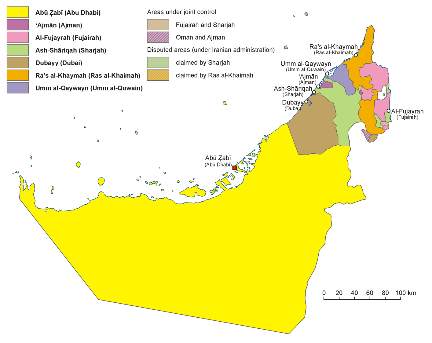
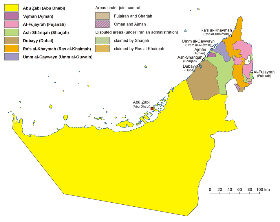
English: Administrative map of the United Arab Emirates in English
فارسی: نقشهٔ اداری امارات متحده عربی به فارسی
Français : Carte des divisions administratives des Emirats arabes unis en Anglais
Italiano: Carta politica degli Emirati Arabi Uniti, in inglese
Hrvatski: Politički zemljovid Ujedinjenih Arapskih Emirata, inačica na engleskom
Polski: Mapa administracyjna Zjednoczonych Emiratów Arabskich, wersja anglojęzyczna
日本語: アラブ首長国連邦の行政区分図(英語版)
Српски / srpski: Политичка карта Уједињених Арапских Емирата, верзија на енглеском језику. |
| Tælmearc | |
| Fruma | Agen weorc, based on map of the United Arab Emirates published in Wielki Encyklopedyczny Atlas Świata (The Great Encyclopedian World Atlas), vol. 10 Azja Południowo-Zachodnia (Southwest Asia), Polish Scientific Publishers PWN, Warsaw 2006, p. 76-78 |
| Dædfruma | Aotearoa |
| Other versions |
Derivative works of this file: |
Leaf:
I, the copyright holder of this work, hereby publish it under the following license:

|
Permission is granted to copy, distribute and/or modify this document under the terms of the GNU Free Documentation License, Version 1.2 or any later version published by the Free Software Foundation; with no Invariant Sections, no Front-Cover Texts, and no Back-Cover Texts. A copy of the license is included in the section entitled GNU Free Documentation License. |
| This file is licensed under the Creative Commons Attribution-Share Alike 3.0 Unported license. | ||
| ||
| This licensing tag was added to this file as part of the GFDL licensing update. |
Ymelan stær
Swing dæg/tide mid mys to seonne þa ymelan swa heo wæs on þære tide geywed.
| Dæg/Tid | Metungincel | Micelnesse gemetu | Brucend | Ymbspræc | |
|---|---|---|---|---|---|
| nu | 10:52, 13 Weodmonað 2013 | | 1,414 × 1,123 (214 KB) | Aotearoa | Reverted to version as of 20:41, 5 January 2007 |
| 17:47, 12 Weodmonað 2013 |  | 1,414 × 1,123 (184 KB) | Cromium | Clarified by removing transliterations of the emirate names, leaving just the English names used in the relevant Wikipedia articles | |
| 20:41, 5 Se Æfterra Gēola 2007 |  | 1,414 × 1,123 (214 KB) | Aotearoa | Administrative map of United Arab Emirates. Created by Aotearoa |
Biliþbendas
Þā folgendan trametas bindaþ tō þissum biliðe:
Ymelan eormen nytt
Þas wiki brucaþ þissa ymelena:
- Nytt on ace.wikipedia.org
- Nytt on af.wikipedia.org
- Nytt on ar.wikipedia.org
- Nytt on ast.wikipedia.org
- Nytt on bn.wikipedia.org
- Nytt on br.wikipedia.org
- Nytt on cs.wikipedia.org
- Spojené arabské emiráty
- Abú Zabí
- Dubaj (emirát)
- Vlajka Spojených arabských emirátů
- Rás al-Chajma (emirát)
- Fudžajra (emirát)
- Abú Zabí (emirát)
- Šablona:Emiráty SAE
- Adžmán (emirát)
- Šardžá (emirát)
- Dubaj
- Fudžajra
- Rás al-Chajma
- Šardžá
- Umm al-Kuvajn (emirát)
- Emiráty Spojených arabských emirátů
- Adžmán
- Umm al-Kuvajn
- Nytt on de.wikipedia.org
- Nytt on en.wikipedia.org
- United Arab Emirates
- User:Jonny-mt/Gallery of current first-level administrative country subdivisions maps
- Template:UAE midsize imagemap with emirate names
- Wikipedia talk:WikiProject Western Asia/Archive 1
- December 1971
- Al Karama, United Arab Emirates
- List of British representatives in the Trucial States
- Nytt on eo.wikipedia.org
- Nytt on es.wikipedia.org
View more global usage of this file.