
Ymele:St Matthew's Church, Rastrick - geograph.org.uk - 77228.jpg
Nænig mare micelness nis brucendlicu.
St_Matthew's_Church,_Rastrick_-_geograph.org.uk_-_77228.jpg (640 × 480 pixela, ymelan micelness: 151 KB, MIME cynn: image/jpeg)
Scortness
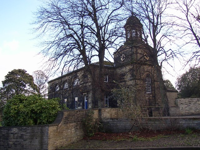
This is a photo of listed building number 1183810. |
| Towritenness |
English: St Matthew's Church, Rastrick. St Matthew's Church was completed in 1798 and has a low west tower with a circular cupola over an octagonal belfry. The side towards the street has five bays with entrances in the first and last. Between these entrances are small rectangular windows set in arched surrounds in which are semi-circular windows with 'spider's web' glazing bars. Inside are three galleries on Tuscan columns. |
| Tælmearc | |
| Fruma | From geograph.org.uk |
| Dædfruma | Humphrey Bolton |
| Hligung (required by the license) | Humphrey Bolton / St Matthew's Church, Rastrick / |
| Object location | | View this and other nearby images on: OpenStreetMap |
|---|
_&language=ang)
Leaf:

|
This image was taken from the Geograph project collection. See this photograph's page on the Geograph website for the photographer's contact details. The copyright on this image is owned by Humphrey Bolton and is licensed for reuse under the Creative Commons Attribution-ShareAlike 2.0 license.
|
This file is licensed under the Creative Commons Attribution-Share Alike 2.0 Generic license.
Hligung: Humphrey Bolton
- Þu most:
- bryttian – to copy, distribute and transmit the work
- to remix – andwendan þæt weorc
- Under the following conditions:
- hlígung – You must give appropriate credit, provide a link to the license, and indicate if changes were made. You may do so in any reasonable manner, but not in any way that suggests the licensor endorses you or your use.
- Efenlice bryttiendlic – Gif þu andwende þis weorc to ohte, þu scleat bryttian þæt andwendede weorc synderlice mid þære ilcan oþþe gelicre leafe swilcre þis brycþ.
Ymelan stær
Swing dæg/tide mid mys to seonne þa ymelan swa heo wæs on þære tide geywed.
| Dæg/Tid | Metungincel | Micelnesse gemetu | Brucend | Ymbspræc | |
|---|---|---|---|---|---|
| nu | 19:26, 30 Se Æfterra Gēola 2010 | | 640 × 480 (151 KB) | GeographBot | == {{int:filedesc}} == {{Information |description={{en|1=St Matthew's Church, Rastrick. St Matthew's Church was completed in 1798 and has a low west tower with a circular cupola over an octagonal belfry. The side towards the street has five bays with ent |
Biliþbendas
Þā folgendan trametas bindaþ tō þissum biliðe:
Ymelan eormen nytt
Þas wiki brucaþ þissa ymelena:
- Nytt on en.wikipedia.org
- Nytt on pl.wikipedia.org
- Nytt on www.wikidata.org