
Ymele:Seine drainage basin.png
Micelness þisre forebysene: 737 be 599 dotta. Oðra metinga brædo: 295 be 240 dotta | 590 be 480 dotta | 974 be 792 dotta.
Frumlicu ymele (974 × 792 pixela, ymelan micelness: 866 KB, MIME cynn: image/png)
Scortness
| Towritenness |
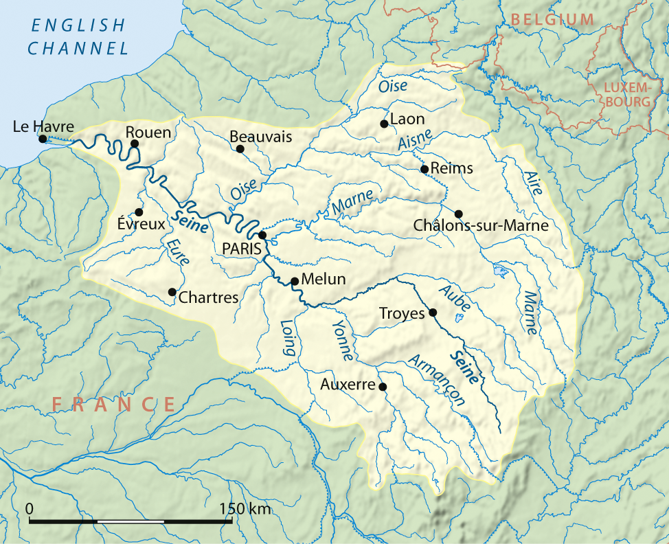
Deutsch: Einzugsgebiet der Seine, englische Version
English: Drainage basin of Seine, English version |
| Tælmearc | |
| Fruma |
Own work using:
|
| Dædfruma | NordNordWest |
| Other versions |
|

|
This map has been made or improved in the German Kartenwerkstatt (Map Lab). You can propose maps to improve as well.
|
Leaf:
I, the copyright holder of this work, hereby publish it under the following licenses:

|
Permission is granted to copy, distribute and/or modify this document under the terms of the GNU Free Documentation License, Version 1.2 or any later version published by the Free Software Foundation; with no Invariant Sections, no Front-Cover Texts, and no Back-Cover Texts. A copy of the license is included in the section entitled GNU Free Documentation License. |
This file is licensed under the Creative Commons Attribution-Share Alike 3.0 Unported license.
- Þu most:
- bryttian – to copy, distribute and transmit the work
- to remix – andwendan þæt weorc
- Under the following conditions:
- hlígung – You must give appropriate credit, provide a link to the license, and indicate if changes were made. You may do so in any reasonable manner, but not in any way that suggests the licensor endorses you or your use.
- Efenlice bryttiendlic – Gif þu andwende þis weorc to ohte, þu scleat bryttian þæt andwendede weorc synderlice mid þære ilcan oþþe gelicre leafe swilcre þis brycþ.
Þu most ceosan leafe
Ymelan stær
Swing dæg/tide mid mys to seonne þa ymelan swa heo wæs on þære tide geywed.
| Dæg/Tid | Metungincel | Micelnesse gemetu | Brucend | Ymbspræc | |
|---|---|---|---|---|---|
| nu | 21:08, 25 Hreðmonað 2008 | | 974 × 792 (866 KB) | NordNordWest | {{Information |Description={{de}} Einzugsgebiet der Seine, englische Version {{en}} Drainage basin of Seine, English version |Source=own work, using * GTOPO-30 Elevation Data by USGS |Date=25-03-2008 |Author= [[User:Titus Groa |
Biliþbendas
Þā folgendan trametas bindaþ tō þissum biliðe:
Ymelan eormen nytt
Þas wiki brucaþ þissa ymelena:
- Nytt on af.wikipedia.org
- Nytt on arc.wikipedia.org
- Nytt on ar.wikipedia.org
- Nytt on bg.wikipedia.org
- Nytt on bn.wikipedia.org
- Nytt on de.wikipedia.org
- Nytt on en.wikipedia.org
- Nytt on eu.wikipedia.org
- Nytt on hr.wikipedia.org
- Nytt on is.wikipedia.org
- Nytt on ka.wikipedia.org
- Nytt on kk.wikipedia.org
- Nytt on mk.wikipedia.org
- Nytt on pnb.wikipedia.org
- Nytt on simple.wikipedia.org
- Nytt on sk.wikipedia.org
- Nytt on uk.wikipedia.org