
Ymele:Roman East 50-en.svg

Size of this PNG preview of this SVG file: 800 be 470 dotta. Oðra metinga brædo: 320 be 188 dotta | 640 be 376 dotta | 1,024 be 601 dotta | 1,280 be 751 dotta | 2,560 be 1,503 dotta | 2,717 be 1,595 dotta.
Frumlicu ymele (SVG ymele, rihte 2,717 × 1,595 pixela, ymelan micelness: 848 KB)
Scortness
| Towritenness |
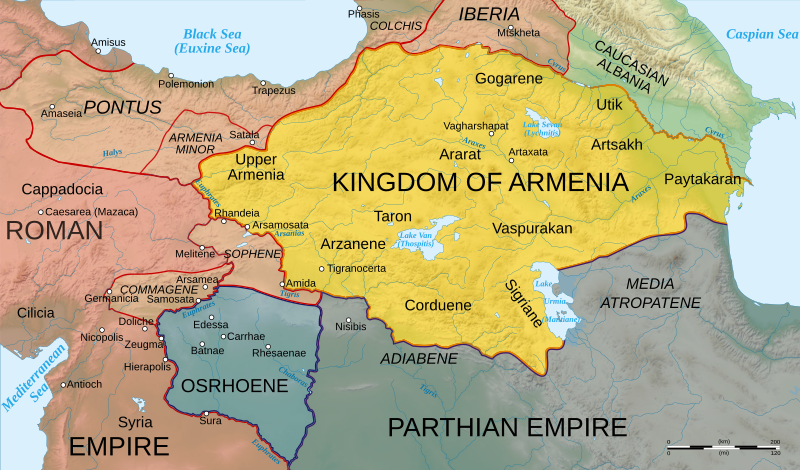
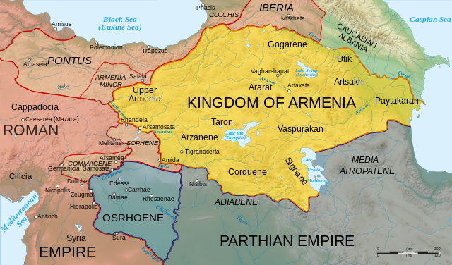
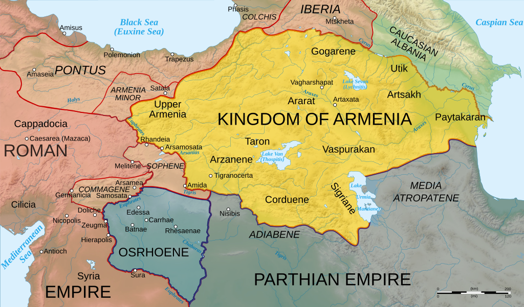
English: Map of Armenia and the Roman client states in eastern Asia Minor, ca. 50 AD, before the Roman-Parthian War and the annexation of the client kingdoms into the Empire. |
| Tælmearc | |
| Fruma | Based on Image:Arshakuni Armenia 150-en.svg. Province & client state outlines based on: Atlas of Classical History, Routledge 1985, pp. 160-162; History Map of Europe, Year 1 from Euratlas |
| Dædfruma | Cplakidas |
| Other versions |
[]
|


This W3C-unspecified vector image was created with Inkscape .
Leaf:
I, the copyright holder of this work, hereby publish it under the following licenses:
This file is licensed under the Creative Commons Attribution-Share Alike 3.0 Unported license.
- Þu most:
- bryttian – to copy, distribute and transmit the work
- to remix – andwendan þæt weorc
- Under the following conditions:
- hlígung – You must give appropriate credit, provide a link to the license, and indicate if changes were made. You may do so in any reasonable manner, but not in any way that suggests the licensor endorses you or your use.
- Efenlice bryttiendlic – Gif þu andwende þis weorc to ohte, þu scleat bryttian þæt andwendede weorc synderlice mid þære ilcan oþþe gelicre leafe swilcre þis brycþ.

|
Permission is granted to copy, distribute and/or modify this document under the terms of the GNU Free Documentation License, Version 1.2 or any later version published by the Free Software Foundation; with no Invariant Sections, no Front-Cover Texts, and no Back-Cover Texts. A copy of the license is included in the section entitled GNU Free Documentation License. |
Þu most ceosan leafe
|
Ymelan stær
Swing dæg/tide mid mys to seonne þa ymelan swa heo wæs on þære tide geywed.
| Dæg/Tid | Metungincel | Micelnesse gemetu | Brucend | Ymbspræc | |
|---|---|---|---|---|---|
| nu | 14:25, 3 Blotmonað 2020 | | 2,717 × 1,595 (848 KB) | ԱշոտՏՆՂ | The Mingechevir Reservoir was built in 1953, so I removed it from the map. |
| 14:07, 13 Eastermonað 2009 |  | 2,717 × 1,595 (854 KB) | Cplakidas | some more details | |
| 06:48, 8 Eastermonað 2009 |  | 2,717 × 1,595 (849 KB) | Cplakidas | trying to fix text problems | |
| 14:35, 7 Eastermonað 2009 |  | 2,717 × 1,595 (863 KB) | Cplakidas | bigger captions, minor tweaks | |
| 18:52, 6 Eastermonað 2009 |  | 2,717 × 1,595 (847 KB) | Cplakidas | plain svg | |
| 18:47, 6 Eastermonað 2009 |  | 2,717 × 1,595 (858 KB) | Cplakidas | {{Information |Description={{en|1=Map of Armenia and the Roman client states in eastern Asia Minor, ca. 50 AD, before the Roman-Parthian War and the annexation of the client kingdoms into the Empire.}} |Source=Based on [[:Image:Arshakuni Armenia 150-en.sv |
Biliþbendas
Þǣr sind nāne trametas þe bindaþ tō þissum biliðe.
Ymelan eormen nytt
Þas wiki brucaþ þissa ymelena:
- Nytt on ar.wikipedia.org
- Nytt on arz.wikipedia.org
- Nytt on azb.wikipedia.org
- Nytt on az.wikipedia.org
- Nytt on be.wikipedia.org
- Nytt on bg.wikipedia.org
- Nytt on ca.wikipedia.org
- Nytt on cs.wikipedia.org
- Nytt on de.wikipedia.org
- Nytt on el.wikipedia.org
- Nytt on en.wikipedia.org
- Germanicus
- Pontus (region)
- Gaius Caesar
- Osroene
- Wikipedia:WikiProject Former countries
- Kingdom of Armenia (antiquity)
- Vologases I of Parthia
- Armenian nobility
- Tiridates I of Armenia
- User:Mcasey666
- Talk:Kingdom of Armenia (antiquity)
- Kingdom of Pontus
- Wikipedia:Featured pictures/Diagrams, drawings, and maps/Maps
- Roman–Parthian War of 58–63
- User:GroveGuy/Sandbox
- User:Cplakidas/Articles
- User:배우는사람/Test
- Classical Anatolia
- User:HistoryofIran/Shervin II
- Wikipedia:Featured pictures thumbs/39
- Kingdom of Bithynia
- Wikipedia:Featured picture candidates/Greater Armenia
- Wikipedia:Featured picture candidates/February-2014
- User talk:Yerevanci/Archive 3
- User talk:Cplakidas/Archive 15
- Wikipedia:Picture of the day/December 2015
- Template:POTD/2015-12-23
- Wikipedia:Main Page history/2015 December 23
- User talk:Cplakidas/Archive 18
- User talk:Yerevanci/Archive 5
- User:Falcaorib
- Wikipedia:WikiProject Former countries/Recognized content
View more global usage of this file.