
Ymele:Montenegro municipalities.png

Micelness þisre forebysene: 464 be 600 dotta. Oðra metinga brædo: 186 be 240 dotta | 371 be 480 dotta | 851 be 1,100 dotta.
Frumlicu ymele (851 × 1,100 pixela, ymelan micelness: 74 KB, MIME cynn: image/png)
Scortness
| Towritenness |
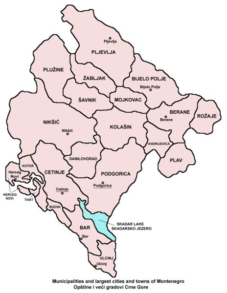
English: Municipalities and largest cities and towns of Montenegro.
Српски / srpski: Opštine i veći gradovi Crne Gore. |
| Tælmearc | 17 Þrimilcemonað 2006 (original upload date) |
| Fruma | Agen weorc |
| Dædfruma | PANONIAN |
Source
From en:Image:Montenegro municipalities.png (created by en:User:PANONIAN)
Leaf:
| I, the copyright holder of this work, release this work into the public domain. This applies worldwide. In some countries this may not be legally possible; if so: I grant anyone the right to use this work for any purpose, without any conditions, unless such conditions are required by law. |
References
- Slobodan Radovanović, Geografski atlas, Magic Map, Smederevska Palanka, 2001.
- Geografski atlas, Intersistem kartografija, Beograd, 2004.
- Miodrag Milošević, Geografija za 8. razred osnovne škole, Beograd, 1994.
Ymelan stær
Swing dæg/tide mid mys to seonne þa ymelan swa heo wæs on þære tide geywed.
| Dæg/Tid | Metungincel | Micelnesse gemetu | Brucend | Ymbspræc | |
|---|---|---|---|---|---|
| nu | 11:43, 20 Gēolmōnaþ 2009 | | 851 × 1,100 (74 KB) | PANONIAN | Reverted to version as of 11:30, 20 December 2009 - fixing thumbnail problem |
| 11:40, 20 Gēolmōnaþ 2009 |  | 1,092 × 1,333 (458 KB) | PANONIAN | Reverted to version as of 06:50, 17 May 2006 - fixing thumbnail problem | |
| 11:30, 20 Gēolmōnaþ 2009 |  | 851 × 1,100 (74 KB) | PANONIAN | improved version | |
| 06:50, 17 Þrimilcemonað 2006 |  | 1,092 × 1,333 (458 KB) | Jeroen | From en:Image:Montenegro municipalities.png (by en:User:PANONIAN Category:Maps of Montenegro |
Biliþbendas
Þā folgendan trametas bindaþ tō þissum biliðe:
Ymelan eormen nytt
Þas wiki brucaþ þissa ymelena:
- Nytt on ace.wikipedia.org
- Nytt on am.wikipedia.org
- Nytt on an.wikipedia.org
- Nytt on arc.wikipedia.org
- Nytt on ar.wikipedia.org
- Nytt on az.wikipedia.org
- Nytt on bat-smg.wikipedia.org
- Nytt on bcl.wikipedia.org
- Nytt on be-tarask.wikipedia.org
- Nytt on bjn.wikipedia.org
- Nytt on bn.wikipedia.org
- Nytt on bo.wikipedia.org
- Nytt on bpy.wikipedia.org
- Nytt on bs.wikipedia.org
- Nytt on ca.wikipedia.org
- Nytt on ceb.wikipedia.org
- Nytt on ckb.wikipedia.org
- Nytt on crh.wikipedia.org
- Nytt on cs.wikipedia.org
- Nytt on cu.wikipedia.org
- Nytt on da.wikipedia.org
- Nytt on diq.wikipedia.org
- Nytt on dsb.wikipedia.org
- Nytt on dv.wikipedia.org
- Nytt on ee.wikipedia.org
- Nytt on el.wikipedia.org
- Nytt on en.wikipedia.org
- Nytt on eo.wikipedia.org
- Nytt on es.wikipedia.org
- Nytt on eu.wikipedia.org
- Nytt on ext.wikipedia.org
- Nytt on fa.wikipedia.org
- Nytt on fiu-vro.wikipedia.org
- Nytt on fi.wikipedia.org
- Nytt on fo.wikipedia.org
- Nytt on frr.wikipedia.org
- Nytt on fr.wikipedia.org
- Nytt on fy.wikipedia.org
- Nytt on ga.wikipedia.org
- Nytt on gl.wikipedia.org
- Nytt on gu.wikipedia.org
- Nytt on ha.wikipedia.org
- Nytt on haw.wikipedia.org
- Nytt on hif.wikipedia.org
View more global usage of this file.