
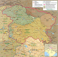
Ymele:Kashmir region 2004.jpg

Micelness þisre forebysene: 604 be 599 dotta. Oðra metinga brædo: 242 be 240 dotta | 484 be 480 dotta | 774 be 768 dotta | 1,032 be 1,024 dotta | 1,579 be 1,567 dotta.
Frumlicu ymele (1,579 × 1,567 pixela, ymelan micelness: 1.71 MB, MIME cynn: image/jpeg)
| Towritenness |
English: Kashmir Region 2004 |
|||
| Tælmearc | ||||
| Fruma | http://www.lib.utexas.edu/maps/middle_east_and_asia/kashmir_region_2004.jpg | |||
| Dædfruma | CIA | |||
| Leaf (Eftnytt þisse ymelan) |
|
|||
| Other versions |
 .jpg)
|


Ymelan stær
Swing dæg/tide mid mys to seonne þa ymelan swa heo wæs on þære tide geywed.
| Dæg/Tid | Metungincel | Micelnesse gemetu | Brucend | Ymbspræc | |
|---|---|---|---|---|---|
| nu | 21:45, 6 Sēremōnaþ 2010 | | 1,579 × 1,567 (1.71 MB) | Ras67 | slightly rotated and cropped |
| 18:46, 7 Hreðmonað 2006 |  | 1,616 × 1,623 (789 KB) | Jungpionier | Kashmir Region 2004 Source URL: [http://www.lib.utexas.edu/maps/middle_east_and_asia/kashmir_region_2004.jpg]. {{PD-USGov-CIA}} |
Biliþbendas
Þā folgendan trametas bindaþ tō þissum biliðe:
Ymelan eormen nytt
Þas wiki brucaþ þissa ymelena:
- Nytt on af.wikipedia.org
- Nytt on ar.wikipedia.org
- Nytt on arz.wikipedia.org
- Nytt on azb.wikipedia.org
- Nytt on az.wikipedia.org
- Nytt on be-tarask.wikipedia.org
- Nytt on be.wikipedia.org
- Nytt on bg.wikipedia.org
- Nytt on bh.wikipedia.org
- Nytt on bn.wikipedia.org
- Nytt on br.wikipedia.org
- Nytt on ca.wikipedia.org
- Nytt on cdo.wikipedia.org
- Nytt on ckb.wikipedia.org
- Nytt on cs.wikipedia.org
- Nytt on da.wikipedia.org
- Nytt on de.wikipedia.org
- Nytt on de.wikinews.org
- Nytt on diq.wikipedia.org
- Nytt on el.wikipedia.org
- Nytt on en.wikipedia.org
View more global usage of this file.