
Ymele:Iran BMNG.png

Micelness þisre forebysene: 652 be 600 dotta. Oðra metinga brædo: 261 be 240 dotta | 522 be 480 dotta | 835 be 768 dotta | 1,113 be 1,024 dotta | 2,104 be 1,935 dotta.
Frumlicu ymele (2,104 × 1,935 pixela, ymelan micelness: 5.6 MB, MIME cynn: image/png)
Scortness
| Towritenness |
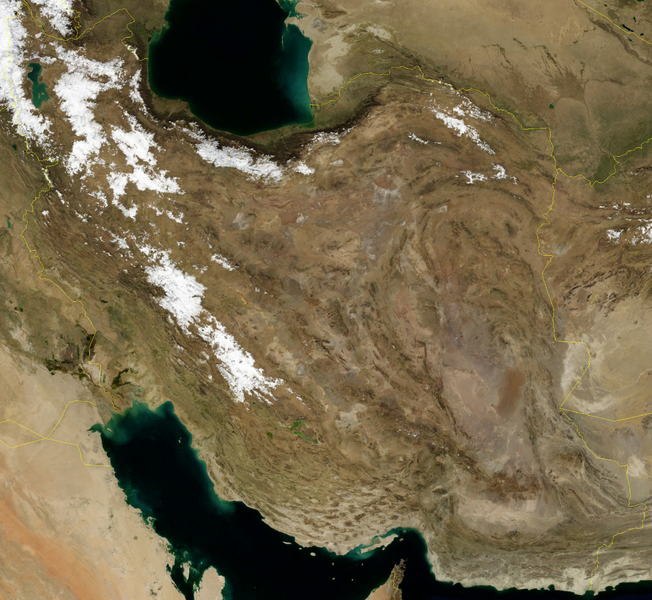
English: Satellite image of Iran in January 2004. |
| Tælmearc | |
| Fruma | Screenshot from NASA World Wind, Blue Marble Next-Generation layer. |
| Dædfruma | NASA |
|
Leaf:
| This image is in the public domain because it is a screenshot from NASA’s globe software World Wind using a public domain layer, such as Blue Marble, MODIS, Landsat, SRTM, USGS or GLOBE.
|
 |
Ymelan stær
Swing dæg/tide mid mys to seonne þa ymelan swa heo wæs on þære tide geywed.
| Dæg/Tid | Metungincel | Micelnesse gemetu | Brucend | Ymbspræc | |
|---|---|---|---|---|---|
| nu | 16:27, 23 Eastermonað 2006 | | 2,104 × 1,935 (5.6 MB) | Hautala | {{PD-WorldWind}} Satellite image of Iran in January 2004. Screenshot from NASA World Wind, Blue Marble Next-Generation layer. Category:Satellite images of countries |
Biliþbendas
Þā folgendan trametas bindaþ tō þissum biliðe:
Ymelan eormen nytt
Þas wiki brucaþ þissa ymelena:
- Nytt on af.wikipedia.org
- Nytt on ar.wikipedia.org
- Nytt on ar.wikiquote.org
- Nytt on bs.wikipedia.org
- Nytt on en.wikipedia.org
- Nytt on en.wikibooks.org
- Nytt on fa.wikipedia.org
- ویکیپدیا:نگارههای برگزیده/نگاه به زمین
- ویکیپدیا:نگاره روز/ژوئن ۲۰۱۶
- ویکیپدیا:گزیدن نگاره برگزیده/Iran BMNG.png
- الگو:نر/2016-06-24
- الگو:نر محافظت شده/2016-06-24
- الگو:کاربر ایرانی ۲
- بحث کاربر:Rab.mj79/بایگانی ۳
- کاربر:Mehdi.salimi742
- کاربر:World and Science
- کاربر:Hossein a 1382
- کاربر:Mj1383
- کاربر:Kazem jalali
- کاربر:Mahdiakhavangood
- کاربر:Daniel twosam
- کاربر:Persianr
- کاربر:Amin13852006
- کاربر:آمانا/درباره من
- کاربر:Reza.langeroodi
- کاربر:Fatemeh m 84
- کاربر:Reza charmahali
- کاربر:عبدالله فردوست
- کاربر:مجید داوودی
- کاربر:Alijopari
- کاربر:Kurd malayeri
- Nytt on fa.wikiquote.org
- Nytt on he.wikipedia.org
- Nytt on hr.wikipedia.org
- Nytt on hu.wikipedia.org
- Nytt on ko.wikipedia.org
- Nytt on pl.wikipedia.org
- Nytt on pt.wikipedia.org
- Nytt on sh.wikipedia.org
- Nytt on sq.wikipedia.org
View more global usage of this file.