
Ymele:Coniston.jpg
Nænig mare micelness nis brucendlicu.
Coniston.jpg (640 × 480 pixela, ymelan micelness: 101 KB, MIME cynn: image/jpeg)
Scortness
| Towritenness |
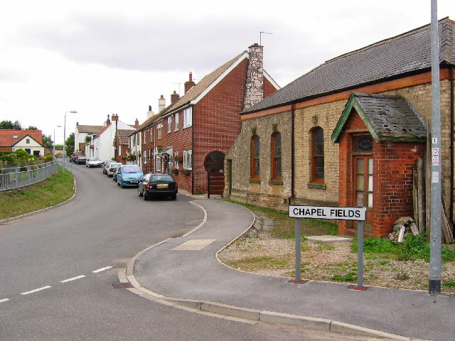
English: Village of Coniston, East Riding of Yorkshire, England. View from the west side of the village looking east. Coniston is situated on the west side of the A165 by-pass, built in 1970 running south to Hull. Within this grid square is Lane End Farm on the west edge. Seen here on the right is the now derelict Primitive Methodist Church. Coniston was known as Coningesbi in 1086, probably an Anglican, Scandinavian mixed name, possibly meaning 'Kings Farm'. |
| Tælmearc | |
| Fruma | From geograph.org.uk |
| Dædfruma | Stephen Horncastle |
| Leaf (Eftnytt þisse ymelan) |
Creative Commons Attribution Share-alike license 2.0 |
| Object location | | View this and other nearby images on: OpenStreetMap |
|---|
_region:GB-GBN_&language=ang)
Leaf:

|
This image was taken from the Geograph project collection. See this photograph's page on the Geograph website for the photographer's contact details. The copyright on this image is owned by Stephen Horncastle and is licensed for reuse under the Creative Commons Attribution-ShareAlike 2.0 license.
|
This file is licensed under the Creative Commons Attribution-Share Alike 2.0 Generic license.
Hligung: Stephen Horncastle
- Þu most:
- bryttian – to copy, distribute and transmit the work
- to remix – andwendan þæt weorc
- Under the following conditions:
- hlígung – You must give appropriate credit, provide a link to the license, and indicate if changes were made. You may do so in any reasonable manner, but not in any way that suggests the licensor endorses you or your use.
- Efenlice bryttiendlic – Gif þu andwende þis weorc to ohte, þu scleat bryttian þæt andwendede weorc synderlice mid þære ilcan oþþe gelicre leafe swilcre þis brycþ.
Ymelan stær
Swing dæg/tide mid mys to seonne þa ymelan swa heo wæs on þære tide geywed.
| Dæg/Tid | Metungincel | Micelnesse gemetu | Brucend | Ymbspræc | |
|---|---|---|---|---|---|
| nu | 14:20, 13 Winterfylleð 2007 | | 640 × 480 (101 KB) | Angusmclellan | {{Information |Description=Village of Coniston in the East Riding of Yorkshire |Source=Geograph project http://www.geograph.org.uk/photo/32493 |Date=Sunday, 31 July, 2005 |Author= |
Biliþbendas
Þā folgendan trametas bindaþ tō þissum biliðe:
Ymelan eormen nytt
Þas wiki brucaþ þissa ymelena:
- Nytt on ceb.wikipedia.org
- Nytt on en.wikipedia.org
- Nytt on fr.wikipedia.org
- Nytt on lld.wikipedia.org
- Nytt on nl.wikipedia.org
- Nytt on pl.wikipedia.org
- Nytt on www.wikidata.org