
Ymele:British kingdoms c 800.svg

Size of this PNG preview of this SVG file: 338 be 599 dotta. Oðra metinga brædo: 135 be 240 dotta | 271 be 480 dotta | 433 be 768 dotta | 578 be 1,024 dotta | 1,156 be 2,048 dotta | 672 be 1,190 dotta.
Frumlicu ymele (SVG ymele, rihte 672 × 1,190 pixela, ymelan micelness: 279 KB)
Scortness
| Towritenness |
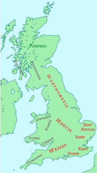
English: This map shows kingdoms in the island of Great Britain at about the year 800. The colors indicate ethnic groups:
|
||
| Tælmearc | |||
| Fruma | self-made. Vectorized version of w:Image:British kingdoms c 800.gif, based on Image:Uk-map.svg (both images are in public domain) | ||
| Dædfruma | Sakurambo | ||
| Leaf (Eftnytt þisse ymelan) |
|
Ymelan stær
Swing dæg/tide mid mys to seonne þa ymelan swa heo wæs on þære tide geywed.
| Dæg/Tid | Metungincel | Micelnesse gemetu | Brucend | Ymbspræc | |
|---|---|---|---|---|---|
| nu | 02:29, 10 Blotmonað 2013 | | 672 × 1,190 (279 KB) | Furfur | colored names |
| 12:21, 15 Solmonaþ 2008 |  | 672 × 1,190 (134 KB) | Sakurambo~commonswiki | revised version with text and colours closer to original | |
| 15:08, 14 Solmonaþ 2008 |  | 722 × 1,190 (166 KB) | Sakurambo~commonswiki | Use outlined fonts instead | |
| 15:05, 14 Solmonaþ 2008 |  | 733 × 1,190 (58 KB) | Sakurambo~commonswiki | {{Information |Description=This map shows kingdoms in the island of Great Britain at about the year 800. |Source=self-made. Vectorized version of en:Image:British kingdoms c 800.gif, based on Image:Uk-map.svg (both images are in public domain) |D |
Biliþbendas
Þā folgendan trametas bindaþ tō þissum biliðe:
Ymelan eormen nytt
Þas wiki brucaþ þissa ymelena:
- Nytt on ar.wikipedia.org
- Nytt on arz.wikipedia.org
- Nytt on ast.wikipedia.org
- Nytt on azb.wikipedia.org
- Nytt on be-tarask.wikipedia.org
- Nytt on be.wikipedia.org
- Nytt on bg.wikipedia.org
- Nytt on br.wikipedia.org
- Nytt on ca.wikipedia.org
- Nytt on cs.wikipedia.org
- Nytt on da.wikipedia.org
- Nytt on de.wikipedia.org
- Nytt on el.wikipedia.org
- Nytt on en.wikipedia.org
View more global usage of this file.