
Ymele:Australian external territories.png
Nænig mare micelness nis brucendlicu.
Australian_external_territories.png (644 × 376 pixela, ymelan micelness: 14 KB, MIME cynn: image/png)

|
This locator map image could be re-created using vector graphics as an SVG file. This has several advantages; see Commons:Media for cleanup for more information. If an SVG form of this image is available, please upload it and afterwards replace this template with
{{vector version available|new image name}}.
It is recommended to name the SVG file “Australian external territories.svg”—then the template Vector version available (or Vva) does not need the new image name parameter. |
Scortness
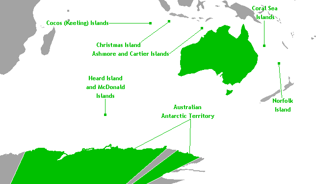
This is a map of Australia's external territories. The base map is Image:Antarctica territorial claims.png by User:Astrokey44 since it shows the AAT. The location of the other territories is Image:BlankMap-World-v6.png by the same user. The previous maps are under the GFDL; therefore, this map is too.
Leaf:
I, the copyright holder of this work, hereby publish it under the following licenses:

|
Permission is granted to copy, distribute and/or modify this document under the terms of the GNU Free Documentation License, Version 1.2 or any later version published by the Free Software Foundation; with no Invariant Sections, no Front-Cover Texts, and no Back-Cover Texts. A copy of the license is included in the section entitled GNU Free Documentation License. |
| This file is licensed under the Creative Commons Attribution-Share Alike 3.0 Unported license. | ||
| ||
| This licensing tag was added to this file as part of the GFDL licensing update. |
Þu most ceosan leafe
Ymelan stær
Swing dæg/tide mid mys to seonne þa ymelan swa heo wæs on þære tide geywed.
| Dæg/Tid | Metungincel | Micelnesse gemetu | Brucend | Ymbspræc | |
|---|---|---|---|---|---|
| nu | 06:40, 18 Blotmonað 2010 | | 644 × 376 (14 KB) | Hoshie | rm boundary lines in Africa, SE Asia, and PNG to focus on Australia and its territories; fixed color of the Comoros |
| 10:00, 17 Hreðmonað 2007 |  | 644 × 376 (14 KB) | Hoshie | This is a map of Australia's external territories. The base map is Image:Antarctica territorial claims.png by User:Astrokey44 since it shows the AAT. The location of the other territories is Image:BlankMap-World-v6.png by the same user. The |
Biliþbendas
Þǣr sind nāne trametas þe bindaþ tō þissum biliðe.
Ymelan eormen nytt
Þas wiki brucaþ þissa ymelena:
- Nytt on af.wikipedia.org
- Nytt on az.wikipedia.org
- Nytt on ba.wikipedia.org
- Nytt on be.wikipedia.org
- Nytt on br.wikipedia.org
- Nytt on bs.wikipedia.org
- Nytt on cs.wikipedia.org
- Nytt on de.wikipedia.org
- Nytt on en.wikipedia.org
- Nytt on eo.wikipedia.org
- Nytt on gl.wikipedia.org
- Nytt on hi.wikipedia.org
- Nytt on hy.wikipedia.org
- Nytt on incubator.wikimedia.org
- Nytt on ka.wikipedia.org
- Nytt on ko.wikipedia.org
- Nytt on lv.wikipedia.org
- Nytt on mr.wikipedia.org
- Nytt on oc.wikipedia.org
- Nytt on pa.wikipedia.org
- Nytt on ru.wikipedia.org
- Nytt on ru.wikinews.org
- Nytt on sh.wikipedia.org
- Nytt on simple.wikipedia.org
- Nytt on sk.wikipedia.org
- Nytt on sr.wikipedia.org
- Nytt on ta.wikipedia.org
- Nytt on th.wikipedia.org
- Nytt on tr.wikipedia.org
- Nytt on vec.wikipedia.org
- Nytt on war.wikipedia.org
- Nytt on xmf.wikipedia.org
- Nytt on zh.wikipedia.org