
Ymele:Aramoana.jpg

Micelness þisre forebysene: 799 be 600 dotta. Oðra metinga brædo: 320 be 240 dotta | 640 be 480 dotta | 1,024 be 768 dotta | 1,280 be 961 dotta | 1,659 be 1,245 dotta.
Frumlicu ymele (1,659 × 1,245 pixela, ymelan micelness: 388 KB, MIME cynn: image/jpeg)
Scortness
| Towritenness |
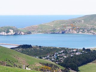
English: Aramoana, Dunedin New Zealand, lower right of photo. Looking east across the entrance of Otago Harbour, from Heyward Point Road. |
| Tælmearc | |
| Fruma | Agen weorc |
| Dædfruma | Benchill |
| Camera location | | View this and other nearby images on: OpenStreetMap |
|---|
Leaf:
| I, the copyright holder of this work, release this work into the public domain. This applies worldwide. In some countries this may not be legally possible; if so: I grant anyone the right to use this work for any purpose, without any conditions, unless such conditions are required by law. |
Ymelan stær
Swing dæg/tide mid mys to seonne þa ymelan swa heo wæs on þære tide geywed.
| Dæg/Tid | Metungincel | Micelnesse gemetu | Brucend | Ymbspræc | |
|---|---|---|---|---|---|
| nu | 08:10, 23 Winterfylleð 2008 | | 1,659 × 1,245 (388 KB) | Benchill | {{Information |Description={{en|1=Aramoana, Dunedin New Zealand, lower right of photo. Looking east across the entrance of Otago Harbour, from Heyward Point Road.}} |Source=Own work by uploader |Author=Benchill |Date=22 |
Biliþbendas
Þā folgendan trametas bindaþ tō þissum biliðe:
Ymelan eormen nytt
Þas wiki brucaþ þissa ymelena:
- Nytt on de.wikipedia.org
- Nytt on en.wikipedia.org
- Nytt on fr.wikipedia.org
- Nytt on pl.wikipedia.org
- Nytt on ru.wikipedia.org
- Nytt on tr.wikipedia.org
- Nytt on www.wikidata.org