
Ymele:Arabian Peninsula dust SeaWiFS-2.jpg

Micelness þisre forebysene: 657 be 600 dotta. Oðra metinga brædo: 263 be 240 dotta | 526 be 480 dotta | 841 be 768 dotta | 1,122 be 1,024 dotta | 2,504 be 2,286 dotta.
Frumlicu ymele (2,504 × 2,286 pixela, ymelan micelness: 867 KB, MIME cynn: image/jpeg)
| Towritenness |
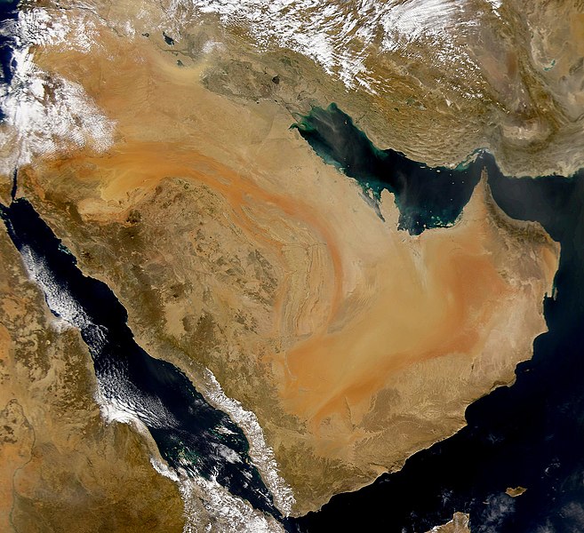
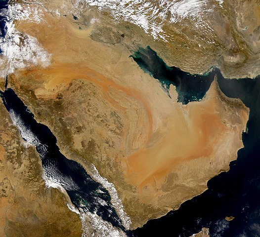
English: SeaWiFS collected this view of the Arabian Peninsula and of dust blowing across the Persian Gulf. Español: La Península Arábiga vista desde el espacio Suomi: Satelliittikuva Arabian niemimaasta
Українська: Компіляція супутникових знімків пилової бурі над Аравійським півостровом, 16 листопада 2008 року. |
| Tælmearc | (UTC) |
| Fruma | |
| Dædfruma |
|
| This is a retouched picture, which means that it has been digitally altered from its original version. Modifications: Enhanced contrast, midtones. The original can be viewed here: Arabian Peninsula dust SeaWiFS.jpg:
|
I, the copyright holder of this work, hereby publish it under the following license:
| This image is from the Sea-viewing Wide Field-of-view Sensor (SeaWiFS) Project and more than 5 years old.
Satellite data captured by the SeaWIFS sensor are released into the public domain 5 years after capture. Data less than five years old can be re-used only for educational or scientific purposes; any commercial use of such images must be coordinated with GeoEye. [1] |
| This work has been released into the public domain by its copyright holder, GeoEye. This applies worldwide. In some countries this may not be legally possible; if so: GeoEye grants anyone the right to use this work for any purpose, without any conditions, unless such conditions are required by law.
|
Original upload log
This image is a derivative work of the following images:
- Image:Arabian_Peninsula_dust_SeaWiFS.jpg licensed with PD-SeaWiFS
- 2008-01-02T17:02:18Z Hautala 2504x2286 (873404 Bytes) {{PD-USGov-NASA}} * {{en|Satellite image of Arabian peninsula}} * {{es|La Península Arábiga vista desde el espacio}} * {{en|Satelliittikuva Arabian niemimaasta}} Taken from NASA's [http://visibleearth.nasa.gov/ Visible E
Uploaded with derivativeFX
Ymelan stær
Swing dæg/tide mid mys to seonne þa ymelan swa heo wæs on þære tide geywed.
| Dæg/Tid | Metungincel | Micelnesse gemetu | Brucend | Ymbspræc | |
|---|---|---|---|---|---|
| nu | 04:59, 16 Blotmonað 2008 | | 2,504 × 2,286 (867 KB) | John Nevard | {{Information |Description={{en|SeaWiFS collected this view of the Arabian Peninsula and of dust blowing across the Persian Gulf.}} {{es|La Península Arábiga vista desde el espacio}} {{en|Satelliittikuva Arabian niemimaasta}} |Source=*[[:Image:Arabian_P |
Biliþbendas
Þā folgendan trametas bindaþ tō þissum biliðe:
Ymelan eormen nytt
Þas wiki brucaþ þissa ymelena:
- Nytt on af.wikipedia.org
- Nytt on ar.wikipedia.org
- Nytt on ar.wikiquote.org
- Nytt on arz.wikipedia.org
- Nytt on awa.wikipedia.org
- Nytt on azb.wikipedia.org
- Nytt on az.wikipedia.org
- Nytt on bcl.wikipedia.org
- Nytt on bh.wikipedia.org
- Nytt on bn.wikipedia.org
- Nytt on ckb.wikipedia.org
- Nytt on da.wikipedia.org
- Nytt on el.wikipedia.org
- Nytt on en.wikipedia.org
- Nytt on en.wikibooks.org
- Nytt on eo.wikipedia.org
- Nytt on es.wikipedia.org
- Nytt on fr.wikibooks.org
- Nytt on ja.wikipedia.org
- Nytt on kab.wikipedia.org
- Nytt on ka.wikipedia.org
- Nytt on ko.wikipedia.org
- Nytt on lb.wikipedia.org
- Nytt on mg.wikipedia.org
- Nytt on mr.wikipedia.org
- Nytt on ms.wikipedia.org
- Nytt on nn.wikipedia.org
- Nytt on no.wikipedia.org
View more global usage of this file.