
Ymele:AntDotMap Livingston.png
Nænig mare micelness nis brucendlicu.
AntDotMap_Livingston.png (200 × 200 pixela, ymelan micelness: 20 KB, MIME cynn: image/png)
Scortness
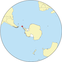
| Towritenness | Location map for the Livingston Island. |
| Tælmearc | |
| Fruma | self-made using Digital Chart of the World data. |
| Dædfruma | Kmusser |
Alternate versions : Image:Livingston-Location.JPG, Image:EarthCenteredOnSouthShetlandIslands.jpg
Leaf:
I, the copyright holder of this work, hereby publish it under the following licenses:

|
Permission is granted to copy, distribute and/or modify this document under the terms of the GNU Free Documentation License, Version 1.2 or any later version published by the Free Software Foundation; with no Invariant Sections, no Front-Cover Texts, and no Back-Cover Texts. A copy of the license is included in the section entitled GNU Free Documentation License. |
This file is licensed under the Creative Commons Attribution-Share Alike 3.0 Unported license.
- Þu most:
- bryttian – to copy, distribute and transmit the work
- to remix – andwendan þæt weorc
- Under the following conditions:
- hlígung – You must give appropriate credit, provide a link to the license, and indicate if changes were made. You may do so in any reasonable manner, but not in any way that suggests the licensor endorses you or your use.
- Efenlice bryttiendlic – Gif þu andwende þis weorc to ohte, þu scleat bryttian þæt andwendede weorc synderlice mid þære ilcan oþþe gelicre leafe swilcre þis brycþ.
Þu most ceosan leafe
Ymelan stær
Swing dæg/tide mid mys to seonne þa ymelan swa heo wæs on þære tide geywed.
| Dæg/Tid | Metungincel | Micelnesse gemetu | Brucend | Ymbspræc | |
|---|---|---|---|---|---|
| nu | 17:07, 8 Se Æfterra Gēola 2008 | | 200 × 200 (20 KB) | Kmusser | == Summary == {{Information |Description= Location map for the Livingston Island. |Source=self-made using Digital Chart of the World data. |Date=September 10,2007 |Author= Kmusser }} == Licensing == {{self|GFDL| |
Biliþbendas
Þā folgendan trametas bindaþ tō þissum biliðe:
Ymelan eormen nytt
Þas wiki brucaþ þissa ymelena:
- Nytt on af.wikipedia.org
- Nytt on ar.wikipedia.org
- Nytt on az.wikipedia.org
- Nytt on be-tarask.wikipedia.org
- Nytt on br.wikipedia.org
- Nytt on da.wikipedia.org
- Nytt on el.wikipedia.org
- Nytt on en.wikipedia.org
- Nytt on eo.wikipedia.org
- Nytt on es.wikipedia.org
- Nytt on eu.wikipedia.org
- Nytt on fi.wikipedia.org
- Nytt on gl.wikipedia.org
- Nytt on id.wikipedia.org
- Nytt on it.wikipedia.org
- Nytt on ja.wikipedia.org
- Nytt on ka.wikipedia.org
- Nytt on ko.wikipedia.org
- Nytt on mk.wikipedia.org
View more global usage of this file.