
Ymele:Mapa administrativo de Chile.png

Micelness þisre forebysene: 366 be 598 dotta. Oðra metinga brædo: 147 be 240 dotta | 293 be 480 dotta | 896 be 1,465 dotta.
Frumlicu ymele (896 × 1,465 pixela, ymelan micelness: 181 KB, MIME cynn: image/png)

|
This image (or all images in this category) uses inside labels or attached captions in a specific script or language and should be converted to a language neutral form. This would allow its use in all Wikimedia projects and, more importantly, all Wikimedia languages.
|
| Towritenness |
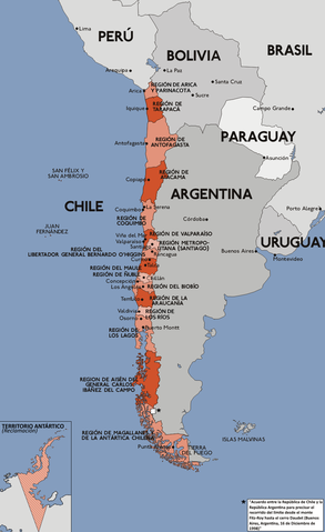
Español: Mapa con la división administrativa de la República de Chile.
Deutsch: Darstellung zeigt die Verwaltungsgliederung von Chile.
English: This diagram shows the administrative districts of Chile.
Français : Ce diagramme montre les districts administratifs du Chili. |
||||||||
| Tælmearc | |||||||||
| Fruma | Karte chile verwaltungsgliederung.png | ||||||||
| Dædfruma | Sansculotte (original), B1mbo | ||||||||
| Leaf (Eftnytt þisse ymelan) |
|

Ymelan stær
Swing dæg/tide mid mys to seonne þa ymelan swa heo wæs on þære tide geywed.
| Dæg/Tid | Metungincel | Micelnesse gemetu | Brucend | Ymbspræc | |
|---|---|---|---|---|---|
| nu | 17:56, 22 Solmonaþ 2018 | | 896 × 1,465 (181 KB) | Janitoalevic | . |
| 17:34, 22 Solmonaþ 2018 |  | 896 × 1,465 (181 KB) | Janitoalevic | Added Ñuble Region | |
| 18:33, 2 Gēolmōnaþ 2017 |  | 896 × 1,465 (171 KB) | Janitoalevic | Fixed borders | |
| 22:47, 22 Mædmonað 2011 |  | 896 × 1,465 (150 KB) | Ras67 | cropped | |
| 18:40, 9 Solmonaþ 2008 |  | 900 × 1,469 (209 KB) | Jorge | Corregí ortografía {{Convert to international}} {{es|Mapa con la división administrativa (1979 - 2006) de la República de Chile. Este mapa está traducido al español en base a Image:Karte chile verwaltungsgliederung.png, crea | |
| 03:28, 3 Winterfylleð 2007 |  | 900 × 1,469 (237 KB) | B1mbo | Agregando nuevas regiones | |
| 22:29, 28 Winterfylleð 2006 |  | 900 × 1,469 (231 KB) | B1mbo | ||
| 22:07, 28 Winterfylleð 2006 |  | 900 × 1,469 (231 KB) | B1mbo | Agregado el Territorio Antártico (reclamación) | |
| 17:33, 4 Haligmonað 2006 |  | 900 × 1,469 (267 KB) | Gonzaloluengo | ||
| 22:35, 25 Se Æfterra Gēola 2006 |  | 900 × 1,469 (190 KB) | B1mbo | de:Bild:Karte chile verwaltungsgliederung.png {{Spanish}} Mapa con la división administrativa (1979 - 2006) de la República de Chile. Este mapa está traducido al español en base a Image:Karte chile verwaltungsgliederung.png, |
Biliþbendas
Þǣr sind nāne trametas þe bindaþ tō þissum biliðe.
Ymelan eormen nytt
Þas wiki brucaþ þissa ymelena:
- Nytt on ace.wikipedia.org
- Nytt on af.wikipedia.org
- Nytt on an.wikipedia.org
- Nytt on awa.wikipedia.org
- Nytt on ay.wikipedia.org
- Nytt on azb.wikipedia.org
- Nytt on bat-smg.wikipedia.org
- Nytt on bcl.wikipedia.org
- Nytt on bh.wikipedia.org
- Nytt on bi.wikipedia.org
- Nytt on bpy.wikipedia.org
- Nytt on bs.wikipedia.org
- Nytt on cbk-zam.wikipedia.org
- Nytt on ceb.wikipedia.org
- Nytt on ch.wikipedia.org
- Nytt on crh.wikipedia.org
- Nytt on cv.wikipedia.org
- Nytt on de.wikipedia.org
- Nytt on diq.wikipedia.org
- Nytt on dsb.wikipedia.org
- Nytt on ee.wikipedia.org
- Nytt on el.wikipedia.org
- Nytt on en.wikibooks.org
- Nytt on eo.wikipedia.org
- Nytt on es.wikipedia.org
- Portal:Lingüística
- Anexo:Puntos extremos de Chile
- Anexo:Gentilicios de Chile
- Anexo:Regiones de Chile por superficie
- Anexo:Especies de coníferas nativas de Chile
- Anexo:Sitios relevantes para la observación de aves en Chile
- Usuario:Sgonzalezb/Reyno de Chile
- Anexo:Regiones de Chile por población
- Anexo:Vertebrados introducidos en Chile
- Vertebrados introducidos en Chile
- Anexo:Regiones de Chile por densidad
- Nytt on es.wikibooks.org
- Nytt on eu.wikipedia.org
- Nytt on fiu-vro.wikipedia.org
- Nytt on frp.wikipedia.org
- Nytt on fur.wikipedia.org
- Nytt on fy.wikipedia.org
- Nytt on ga.wikipedia.org
- Nytt on gd.wikipedia.org
- Nytt on got.wikipedia.org
- Nytt on gu.wikipedia.org
- Nytt on hr.wikipedia.org
- Nytt on hu.wikipedia.org
View more global usage of this file.