
Ymele:Map of Bengal.svg

Size of this PNG preview of this SVG file: 656 be 599 dotta. Oðra metinga brædo: 263 be 240 dotta | 526 be 480 dotta | 841 be 768 dotta | 1,121 be 1,024 dotta | 2,242 be 2,048 dotta | 1,835 be 1,676 dotta.
Frumlicu ymele (SVG ymele, rihte 1,835 × 1,676 pixela, ymelan micelness: 1.32 MB)
Scortness
| Towritenness |
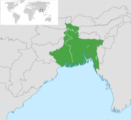
English: Map of Bengal. The region is today divided between East Bengal (Bangladesh) and West Bengal. Also showing the state of Tripura and the three districts of Cachar, Hailakandi and Karimganj; part of Barak Valley in Assam, India. Svenska: Karta av Bengal, delad mellan östra och västra. Staten Tripura och distrikten Hailakandi och Karimganj i södra Assam visas också. বাংলা: বাংলার মানচিত্র, পূর্ব ও পশ্চিমের মধ্যে বিভক্ত করা। মানচিত্রে চিহ্নিত রয়েছে বাংলাদেশের পূর্বে অবস্থিত বাংলাভাষী ভারতীয় রাজ্য ত্রিপুরা সহ আসাম রাজ্যের বরাক উপত্যকার তিনটি জেলা কাছাড়, হাইলাকান্দি এবং করিমগঞ্জ। |
| Tælmearc | |
| Fruma |
|
| Dædfruma | Goran tek-en |
| SVG genesis |

.svg)

Leaf:
This file is licensed under the Creative Commons Attribution-Share Alike 4.0 International license.
Hligung: Goran tek-en
- Þu most:
- bryttian – to copy, distribute and transmit the work
- to remix – andwendan þæt weorc
- Under the following conditions:
- hlígung – You must give appropriate credit, provide a link to the license, and indicate if changes were made. You may do so in any reasonable manner, but not in any way that suggests the licensor endorses you or your use.
- Efenlice bryttiendlic – Gif þu andwende þis weorc to ohte, þu scleat bryttian þæt andwendede weorc synderlice mid þære ilcan oþþe gelicre leafe swilcre þis brycþ.
Ymelan stær
Swing dæg/tide mid mys to seonne þa ymelan swa heo wæs on þære tide geywed.
| Dæg/Tid | Metungincel | Micelnesse gemetu | Brucend | Ymbspræc | |
|---|---|---|---|---|---|
| nu | 10:03, 2 Blotmonað 2022 | | 1,835 × 1,676 (1.32 MB) | MS Sakib | Reverted to version as of 18:02, 10 March 2022 (UTC) (tripura and barak area are included in bengal region!) |
| 05:28, 4 Winterfylleð 2022 |  | 1,835 × 1,676 (1.31 MB) | Msasag | Reverted to version as of 16:42, 4 October 2016 (UTC) | |
| 18:02, 10 Hreðmonað 2022 |  | 1,835 × 1,676 (1.32 MB) | MS Sakib | Barak Valley area fixed | |
| 11:25, 12 Blotmonað 2017 |  | 1,835 × 1,676 (1.32 MB) | Mouryan | =={{int:filedesc}}== {{Information |description={{en|1=Map of Bengal, divided between east and west.}}{{sv|1=Karta av Bengal, delad mellan östra och västra.}}{{bn|1=বাংলার মানচিত্র, পূর্ব ও পশ্চিম... | |
| 16:42, 4 Winterfylleð 2016 |  | 1,835 × 1,676 (1.31 MB) | BurritoBazooka | fix minimap bg turning up transparent in thumbnail? | |
| 16:40, 4 Winterfylleð 2016 |  | 1,835 × 1,676 (1.31 MB) | BurritoBazooka | paste File:BlankMap-World gray.svg in again for minimap, this time with Alaska and Lesotho. | |
| 17:13, 1 Gēolmōnaþ 2013 |  | 1,835 × 1,676 (1.19 MB) | Goran tek-en | Enlarged map ~~~~ | |
| 17:53, 30 Blotmonað 2013 |  | 1,836 × 1,679 (1.2 MB) | Goran tek-en | User created page with UploadWizard |
Biliþbendas
Þā folgendan trametas bindaþ tō þissum biliðe:
Ymelan eormen nytt
Þas wiki brucaþ þissa ymelena:
- Nytt on af.wikipedia.org
- Nytt on ar.wikipedia.org
- Nytt on ast.wikipedia.org
- Nytt on as.wikipedia.org
- Nytt on azb.wikipedia.org
- Nytt on az.wikipedia.org
- Nytt on az.wikiquote.org
- Nytt on be.wikipedia.org
- Nytt on bg.wikipedia.org
- Nytt on bn.wikipedia.org
- টেমপ্লেট:ব্যবহারকারী/বাঙালি
- বঙ্গ
- ব্যবহারকারী:Snthakur
- ব্যবহারকারী:Wiki naogaon
- বঙ্গভঙ্গ (১৯৪৭)
- ব্যবহারকারী:Ali Haidar Khan
- ব্যবহারকারী:Tanveer.nonstop
- ব্যবহারকারী:Faysal
- ব্যবহারকারী:Jonoikobangali
- ব্যবহারকারী:Jayantanth/Userboxes
- ব্যবহারকারী:Yahia.barie
- ব্যবহারকারী:Tarunno
- ব্যবহারকারী:Ikfaisal
- প্রবেশদ্বার:বাংলাদেশ
- ব্যবহারকারী:Pasaban
- ব্যবহারকারী:Wildscop
- ব্যবহারকারী:Rezowan
- ব্যবহারকারী:ছেঁড়াবাকল
- ব্যবহারকারী:DesiNinja
- ব্যবহারকারী:Hemayet
- ব্যবহারকারী:Hemayetfaridpur
- ব্যবহারকারী:004satcho
- ব্যবহারকারী:Babaidmun
- ব্যবহারকারী:Bodhisattwa
- ব্যবহারকারী:Akramul Hoque Samim
- ব্যবহারকারী:শাহনেওয়াজ শুভ
- ব্যবহারকারী:Muhammad Tasbir Iftekhar
- ব্যবহারকারী:Mohd. Toukir Hamid
- ব্যবহারকারী:ইউক্লিড রনি
- ব্যবহারকারী:Sukanta Sarkar
- ব্যবহারকারী:Ashiq Shawon
- ব্যবহারকারী:Asaduzzamana
- ব্যবহারকারী:Akash Islam
- ব্যবহারকারী:Sabarni sarker
- ব্যবহারকারী:হাসান মাহমুদ
- ব্যবহারকারী:Md.Faysal Alam Riyad
- ব্যবহারকারী:ANKAN
View more global usage of this file.