
Ymele:LocationLiechtenstein.png
Nænig mare micelness nis brucendlicu.
LocationLiechtenstein.png (250 × 115 pixela, ymelan micelness: 6 KB, MIME cynn: image/png)
Scortness
| Towritenness |
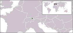
English: Location map for Liechtenstein.
Deutsch: Karte zur Lage von Liechtenstein. |
|||
| Tælmearc | ||||
| Fruma | Originally created for English Wikipedia by Vardion. | |||
| Dædfruma | Vardion | |||
| Other versions |
|


Leaf:
| |
This work has been released into the public domain by its author, Vardion, at the English Ƿikipǣdia project. This applies worldwide. In case this is not legally possible: |
| Annotations | This image is annotated: View the annotations at Commons |
Ymelan stær
Swing dæg/tide mid mys to seonne þa ymelan swa heo wæs on þære tide geywed.
| Dæg/Tid | Metungincel | Micelnesse gemetu | Brucend | Ymbspræc | |
|---|---|---|---|---|---|
| nu | 05:59, 16 Gēolmōnaþ 2004 | | 250 × 115 (6 KB) | EugeneZelenko | Location map for the Liechtenstein.<br/>Originally created for English Wikipedia by Vardion.<br/>{{PD}}<br/>Category:Country locator maps |
| 15:11, 12 Gēolmōnaþ 2004 |  | 250 × 115 (6 KB) | SpeedyGonsales | Location Liechtenstein |
Biliþbendas
Þǣr sind nāne trametas þe bindaþ tō þissum biliðe.
Ymelan eormen nytt
Þas wiki brucaþ þissa ymelena:
- Nytt on als.wikipedia.org
- Nytt on arc.wikipedia.org
- Nytt on av.wikipedia.org
- Nytt on bg.wikipedia.org
- Nytt on bpy.wikipedia.org
- Nytt on br.wikipedia.org
- Nytt on ceb.wikipedia.org
- Nytt on ckb.wikipedia.org
- Nytt on cv.wikipedia.org
- Nytt on de.wikipedia.org
- Nytt on de.wikibooks.org
- Nytt on de.wikinews.org
- Nytt on de.wiktionary.org
- Nytt on dsb.wikipedia.org
- Nytt on el.wiktionary.org
- Nytt on en.wikipedia.org
- Nytt on en.wikivoyage.org
- Nytt on en.wiktionary.org
- Nytt on eo.wikipedia.org
- Nytt on eo.wiktionary.org
- Nytt on eu.wiktionary.org
- Nytt on fa.wikipedia.org
- Nytt on fiu-vro.wikipedia.org
- Nytt on fr.wikipedia.org
- Nytt on fr.wikinews.org
- Nytt on fy.wikipedia.org
- Nytt on gu.wikipedia.org
- Nytt on he.wikivoyage.org
- Nytt on hif.wikipedia.org
- Nytt on ht.wikipedia.org
- Nytt on ia.wikipedia.org
- Nytt on id.wikipedia.org
- Nytt on incubator.wikimedia.org
- Nytt on it.wikivoyage.org
- Nytt on ja.wikipedia.org
- Nytt on jv.wikipedia.org
- Nytt on ka.wiktionary.org
View more global usage of this file.