
Ymele:Klimagürtel-der-erde.png

Micelness þisre forebysene: 800 be 400 dotta. Oðra metinga brædo: 320 be 160 dotta | 640 be 320 dotta | 1,024 be 512 dotta | 1,280 be 640 dotta | 3,600 be 1,800 dotta.
Frumlicu ymele (3,600 × 1,800 pixela, ymelan micelness: 591 KB, MIME cynn: image/png)
Scortness
| Towritenness |
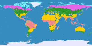
English: This map shows the Earth zones with tropical climate.
Ice cap climate Tundra climate Boreal climate Warm temperate climate Subtropical climate Tropical climate
Deutsch: Diese Karte stellt die Klimagürtel der Erde dar.
Eisklima Tundrenklima Boreales Klima Warmgemäßigtes Klima Subtropisches Klima Tropisches Klima
Ελληνικά: Αυτός ο χάρτης δείχνει τις ζώνες της γης με τροπικό κλίμα.
Πολικό κλίμα Κλίμα τούνδρας Αρκτικό κλίμα Εύκρατο κλίμα Υποτροπικό κλίμα Τροπικό κλίμα
Português: Este mapa mostra as áreas do planeta Terra com clima tropical.
Clima Polar Clima de Tundra Clima Boreal Clima Temperado Clima Subtropical Clima Tropical
Español: Este mapa muestra las zonas de la Tierra con clima tropical.
Clima Polar Clima de Tundra Clima Boreal Clima Templado Clima Subtropical Clima Tropical |
|||
| Tælmearc | ||||
| Fruma |
English: Own work on the basis of the following data: Deutsch: Selbst erstellt auf Basis dieser Geodaten:
|
|||
| Dædfruma | ||||
| Other versions |
|


Leaf:
This file is licensed under the Creative Commons Attribution-Share Alike 3.0 Unported license.
- Þu most:
- bryttian – to copy, distribute and transmit the work
- to remix – andwendan þæt weorc
- Under the following conditions:
- hlígung – You must give appropriate credit, provide a link to the license, and indicate if changes were made. You may do so in any reasonable manner, but not in any way that suggests the licensor endorses you or your use.
- Efenlice bryttiendlic – Gif þu andwende þis weorc to ohte, þu scleat bryttian þæt andwendede weorc synderlice mid þære ilcan oþþe gelicre leafe swilcre þis brycþ.
Ymelan stær
Swing dæg/tide mid mys to seonne þa ymelan swa heo wæs on þære tide geywed.
| Dæg/Tid | Metungincel | Micelnesse gemetu | Brucend | Ymbspræc | |
|---|---|---|---|---|---|
| nu | 19:08, 24 Sēremōnaþ 2017 | | 3,600 × 1,800 (591 KB) | Alatab | Costa Rican Central Valley has a Cwb clasification (Oceanic climate). |
| 21:01, 11 Winterfylleð 2016 |  | 3,600 × 1,800 (765 KB) | Maphobbyist | The Caspian Sea was omitted. The Köppen system is based on the concept that climate types are correlated with the natural vegetation. | |
| 14:50, 15 Winterfylleð 2007 |  | 3,600 × 1,800 (662 KB) | Lortordermur | == Beschreibung == {{Information |Description=Diese Karte stellt die Klimagürtel der Erde dar. {{legend|#eaeaff|Eisklima}} {{legend|#19ebed|Tundrenklima}} {{legend|#e465e6|Boreales Klima}} {{legend|#2a982a|Warmgemäßigtes Klima}} {{legend|#ffcc00|Su | |
| 20:27, 23 Þrimilcemonað 2007 |  | 3,445 × 1,731 (704 KB) | Lortordermur | {{Information |Description=Diese Karte stellt die Klimagürtel der Erde dar. {{legend|#eaeaff|Eisklima}} {{legend|#19ebed|Tundrenklima}} {{legend|#e465e6|Boreales Klima}} {{legend|#2a982a|Warmgemäßigtes Klima}} {{legend|#ffcc00|Subtropisches Klima}} |
Biliþbendas
Þā folgendan trametas bindaþ tō þissum biliðe:
Ymelan eormen nytt
Þas wiki brucaþ þissa ymelena:
- Nytt on ast.wikipedia.org
- Nytt on be.wikipedia.org
- Nytt on bg.wikipedia.org
- Nytt on bn.wikipedia.org
- Nytt on bs.wikipedia.org
- Nytt on ca.wikipedia.org
- Nytt on ce.wikipedia.org
- Nytt on el.wikipedia.org
- Nytt on en.wikipedia.org
- Nytt on eo.wikipedia.org
- Nytt on et.wikipedia.org
- Nytt on eu.wikipedia.org
- Nytt on fa.wikipedia.org
- Nytt on fi.wikipedia.org
- Nytt on fr.wikipedia.org
- Nytt on gl.wikipedia.org
- Nytt on he.wiktionary.org
- Nytt on hi.wikipedia.org
- Nytt on hy.wikipedia.org
- Nytt on id.wikipedia.org
- Nytt on is.wikipedia.org
- Nytt on it.wikipedia.org
- Nytt on it.wikibooks.org
- Nytt on it.wikiversity.org
- Nytt on kk.wikipedia.org
- Nytt on la.wikipedia.org
- Nytt on mk.wikipedia.org
- Nytt on my.wikipedia.org
- Nytt on nn.wikipedia.org
- Nytt on no.wikipedia.org
- Nytt on ro.wikipedia.org
- Nytt on ru.wikipedia.org
- Nytt on simple.wikipedia.org
- Nytt on si.wikipedia.org
- Nytt on sv.wikipedia.org
- Nytt on ta.wikipedia.org
- Nytt on uk.wikipedia.org
- Nytt on vi.wikipedia.org
- Nytt on zh-min-nan.wikipedia.org