
Ymele:Flusssystemkarte Rhein 04.jpg

Micelness þisre forebysene: 441 be 599 dotta. Oðra metinga brædo: 177 be 240 dotta | 353 be 480 dotta | 565 be 768 dotta | 754 be 1,024 dotta | 1,508 be 2,048 dotta | 3,198 be 4,344 dotta.
Frumlicu ymele (3,198 × 4,344 pixela, ymelan micelness: 11.72 MB, MIME cynn: image/jpeg)
Scortness
| Towritenness |
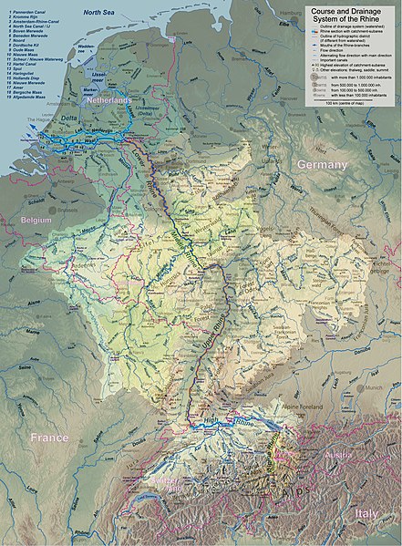
English: Rhine course and river system, place names in English Deutsch: Rheinlauf und Flusssystem, englisch beschriftet Français : Cours du Rhin et son bassin versant, noms de lieux en anglais Nederlands: Verloop en rivierensysteem van de Rijn, plaatsnamen in Engels |
| Tælmearc | |
| Fruma | Agen weorc |
| Dædfruma | WWasser |
| Other versions | Versions in german, french, dutch, or with local names. For other languages the unlabelled version may be used. There are also less detailed maps of the river system with either german, english, french, dutch, or local names. A small version without names is available, too. |
| Camera location | | View this and other nearby images on: OpenStreetMap |
|---|
- Background relief created with Google Maps-For-Free SRTM3 Webserver
- Topography derived from Open Street Map
- Outlines of catchment areas derived from relief data (in the Netherlands also taken from several ICPR (International Commission for the Protection of the Rhine)- and Rijkswaterstaat-publications)
Leaf:
I, the copyright holder of this work, hereby publish it under the following license:
This file is licensed under the Creative Commons Attribution-Share Alike 3.0 Unported license.
- Þu most:
- bryttian – to copy, distribute and transmit the work
- to remix – andwendan þæt weorc
- Under the following conditions:
- hlígung – You must give appropriate credit, provide a link to the license, and indicate if changes were made. You may do so in any reasonable manner, but not in any way that suggests the licensor endorses you or your use.
- Efenlice bryttiendlic – Gif þu andwende þis weorc to ohte, þu scleat bryttian þæt andwendede weorc synderlice mid þære ilcan oþþe gelicre leafe swilcre þis brycþ.
Ymelan stær
Swing dæg/tide mid mys to seonne þa ymelan swa heo wæs on þære tide geywed.
| Dæg/Tid | Metungincel | Micelnesse gemetu | Brucend | Ymbspræc | |
|---|---|---|---|---|---|
| nu | 18:26, 17 Haligmonað 2017 | | 3,198 × 4,344 (11.72 MB) | WWasser | Albertkanaal, Aa (Dommel), frontier lines in Lake of Constance |
| 12:23, 18 Eastermonað 2013 |  | 2,399 × 3,255 (4.7 MB) | WWasser | more details | |
| 16:34, 4 Eastermonað 2013 |  | 2,131 × 2,892 (4.22 MB) | WWasser | {{Information |Description ={{en|1=legend and colours, more toponyms translated}} |Source =own work |Author =own work |Date = |Permission = |other_versions = }} | |
| 13:49, 5 Hreðmonað 2013 |  | 2,131 × 2,894 (3.32 MB) | WWasser | some smaller rivers, elevations | |
| 12:56, 8 Solmonaþ 2013 |  | 2,131 × 2,896 (3.07 MB) | WWasser | {{Information |Description ={{en|1=colours improved}} |Source =own |Author =WWasser |Date = |Permission = |other_versions = }} | |
| 09:03, 8 Solmonaþ 2013 |  | 2,131 × 2,896 (3.11 MB) | WWasser | {{Information |Description ={{en|1=lower, more appropriate resolution}} |Source =own |Author =User:WWasser|WWasser |Date =2013-02-05 |Permission = |other_versions = }} | |
| 16:04, 5 Solmonaþ 2013 |  | 4,262 × 5,791 (4.22 MB) | WWasser | User created page with UploadWizard |
Biliþbendas
Þā folgendan trametas bindaþ tō þissum biliðe:
Ymelan eormen nytt
Þas wiki brucaþ þissa ymelena:
- Nytt on ast.wikipedia.org
- Nytt on as.wikipedia.org
- Nytt on av.wikipedia.org
- Nytt on azb.wikipedia.org
- Nytt on ban.wikipedia.org
- Nytt on ba.wikipedia.org
- Nytt on be-tarask.wikipedia.org
- Nytt on be.wikipedia.org
- Nytt on bh.wikipedia.org
- Nytt on da.wikipedia.org
- Nytt on en.wikipedia.org
- Nytt on fa.wikipedia.org
- Nytt on gv.wikipedia.org
- Nytt on he.wikipedia.org
- Nytt on hi.wikipedia.org
- Nytt on id.wikipedia.org
- Nytt on ilo.wikipedia.org
- Nytt on kk.wikipedia.org
- Nytt on kw.wikipedia.org
- Nytt on lfn.wikipedia.org
- Nytt on lij.wikipedia.org
- Nytt on ml.wikipedia.org
- Nytt on nl.wikipedia.org
- Nytt on ru.wikipedia.org
- Nytt on sco.wikipedia.org
- Nytt on sd.wikipedia.org
- Nytt on simple.wikipedia.org
- Nytt on th.wikipedia.org
- Nytt on tr.wikipedia.org